|
|
|
| Tales from the Woods |
|
|
| 06-08-2010 |
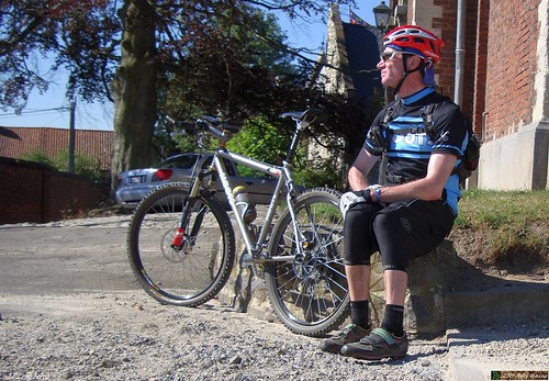
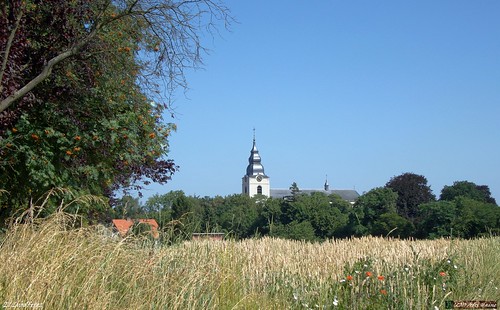
 Haasrode TT 65K recon Haasrode TT 65K recon |
Had the idea to ride the track from the 2008 Haasrode TT again. Or at least what I call the raw track. The actual TT cut some corners here and there to soften things up a bit and keep the actual distance below 65K. This is what you might call the heavy duty version. I put the track into my Edge 705 and reversed it. I also rode this track in november 2008 so you can check my story there for more details and a view of the map.
I didn't pass through Haasrode today since I cut the track short starting in Blanden and staying in Meerdael Forest instead of riding the last and first couple of K's to and from the start.
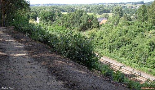
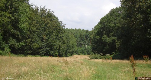
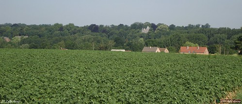
First passing in Mollendaalbos and then exiting the green and cool Meerdael forest near Valduc where the sun was awaiting me. Through Tourinnes la Grosse and then moving south towards Gottechain. Here the serious things start as the ride moves towards Pietrebais and Cocrou. Even further south to reach Longueville where a lot of heightmeters make the gears, and my legs , grind. When I finally reach Heze I already have 600 heightmeters and 47K.
I then move towards Grez Doiceau and Gottechain again where a mean climb awaits me. Towards Archennes and then up the crest to connect to Nethen. Disappearing into Meerdael Forest for a loop that takes me back down towards Nethen. Here I have to climb towards the Bois de Beaumont where I can enjoy a lovely view of Nethen basking in the evening sun.
Down towards Nethen again and passing the camping La Hetraie I stop and have a drink at the well. Climbing again towards the Kluis where I join the Blue Bloso. Down past the Kluis main building , up the hill and back down again towards the Savenel. The passage in the deep sand just before the climb makes me dig deep into my strenght. And I am glad when I close the loop I started at the Naamsesteenweg. This is indeed a difficult track and it would be a real challenge to let the TT riders to this track. But the final track will differ I'm sure. Nevertheless it will make a lot of riders suffer on August 22nd, when the organised ride starts at the Sports Complex in Haasrode. This is one of the better rides in this region, so why not try it yourself?
Ride Stats : 70K and 830/975 heightmeters (Polar/Garmin) in 4h5mins30secs
6088/64305
06-08-2010, 21:33 geschreven door Big Bad Wolf
|
|
|
|
|
| 01-08-2010 |
| Blue Green Blue Red Blue |

Sunny and not too warm, ideal weather for a ride in my local forest. I decided to do the 3 Meerdael BLOSO trails, connecting them starting with the Blue, then hop on the Green and do that until it meets the Blue again, near the Zoete Waters, then follow the Blue for what is the more hilly part of these trails. The Blue then connects to the Red which again I follow completely until it connects with the Blue again. Then it is just a short bit left to where I started my loop a while back.
The trails were in good condition, although the part near the wall in Nethen was extra sandy, almost to the point of being impossible to ride. But looking at the clouds as I type this, I think we might see some rain soon, which will certainly harden up the sandy bits.
Ride Stats : 55,5K and 465/560 heightmeters (Polar/Garmin) in 2h48mins
5958/62550
01-08-2010, 14:09 geschreven door Big Bad Wolf
|
|
|
|
|
| 30-07-2010 |
| Chaumont Gistoux on the road |
When I was riding towards the track of the Rando des Coquelicots in Chaumont Gistoux last wednesday I noticed some green arrowing on the road that looked quite fresh. I made a mental note to come back and see where they would lead.
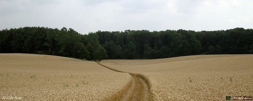
So today I rode towards Grez where I had noticed a 60K/90K split of those arrows. I decided to try the 60K ride. It turned out -as I half suspected - that this ride also started at the Ronvau in Chaumont where the MTB rando starts. Riding through Bonlez towards Chaumont the track then makes a fine loop towards Sart Risbart, Opprebais, Maleves Sainte Marie Wastinnes and Perwez. Here it moves towards Orbais , Nil St Vincent and Walhain to arrive in Corroy-Le-Grand where it crosses the MTB trail. I know this because I only rode it last wednesday, remember?
From Corroy it moves towards Gistoux again but adds another loop towards Wavre before actually arriving back at Grez Doiceau. I add another little loop over Bossut on my way back towards Hamme Mille and Meerdael Forest. The ride started with a lot of clouds but gradually the sun broke through and the wind - which was blowing noticeably from the southwest - diminished on strength towards the end of the ride .
Ride Stats : 87,5K and 590/665 heightmeters (Polar/Garmin) in 3h59mins
5903/61990
30-07-2010, 15:56 geschreven door Big Bad Wolf
|
|
|
|
|
| 28-07-2010 |
| Chaumont Gistoux 2010 |

I was unable to attend the Chaumont Gistoux organised ride - the rando des cocquelicots - earlier this year, so I was glad that my friend Roger sent me the GPS track of the 45K distance. That way I could ride this track whenever I chose to do so. Today looked like a good day for it. The forecast called for cloudy skies, a small chance of a shower, and temperatures around 20 degrees C.
So I rode out towards Grez Doiceau, where I could pick in on the track. I noticed that the cool wind from earlier this week was gone, instead the wind felt a lot warmer. Due to me wearing long sleeved trousers and shirts, that was not a good thing. But the alternative was even worse so I gritted my teeth and wore my cross with pride.
The trail then : from Grez it turns towards Cocrou where a long climb in a sandy hollow road awaits. Good thing it had rained a little bit which made the sand just hard enough to ride it. I have been here many times before and when this sand is really dry, you walk. After this climb a drop into a green valley near Longueville and a passage along the Chapelle du Cheneau before dropping into the Heze valley.
Here the trail makes a couple of twists and turns, just touching the border of Bonlez before climbing back to the west in the direction of Longueville again. From Longueville there is a section with field roads bringing me towards Sart Risbart but turning to the south and dropping into Chaumont. Here I pass the official start of the ride, at the Sports Complex in the Rue Ronvau. From now on I come in lesser known areas and I enjoy a couple of nice sections along small singletracks between meadows and in hollow roads.


The ride turns towards Corroy-Le-Grand, the southernmost point of this track. Then it veers to the right in the direction of Louvain la Neuve. Through the Bois de Vieusart and next to a beautiful castle which sadly is hidden mostly by the green of the trees. Down towards Brocsous through a nice singletrack in a deep rift surrounded by houses, which you don't see fortunately. After a while the N243 is crossed and a steep climb brings me to the 2 chapelles high above Wavre. Long downhill into Dion Valmont. I am now back into Accro Bike country and after a while I pass Doiceau and then take the last climb of the Accro Bike race up towards Bercuit. Just a long drop into Grez now, a couple of backroads and I am back where I started out, 44K and 650 heightmeters have passed my wheels on this track. Not too bad but beware of doing this trail after heavy rains. It turns into quite a different beast.
From Grez I make my way back home over the plains east of Gottechain towards Hamme Mille, where I make an extra loop through the Domaine de Valduc. I had noticed black clouds gathering and indeed, 15 minutes after I arrive home a short thunderstorm breaks out.
I include the track from my ride today. Please note that it starts in Grez Doiceau, and passes the official start of the TT after about 22K.
Ride Stats : 71K and 805/870 heightmeters (Polar/Garmin) in 3h54mins
5815/61325
28-07-2010, 00:00 geschreven door Big Bad Wolf
|
|
|
|
|
| 26-07-2010 |
| Climb thou shalt |

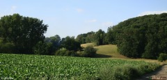
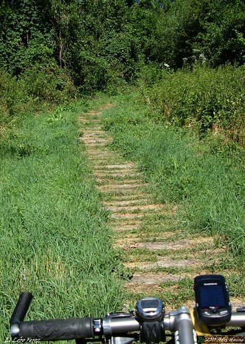
Great biking weather today. The sun was not to be seen, there was a cloud cover with just a whisper of rain and the temperatures were around 20 degrees Celcius. The wind was blowing strong from the northwest and I decided to take the Moots YBB out for an offroad adventure. First I made my way through Meerdael Forest towards Pecrot where I picked up on the 2010 Meerdael Classic 100K trail. This section I already did a couple of weeks ago and it is an amazing succession of climbs and descents, making for a great track to do some intense training on. The cool weather made it easier for me to find my strength and keep on riding for longer. The first couple of climbs, into the Bois de Laurensart and up to Ottenburg comfirmed my initial feeling that my legs were good. I had 2 Mountain Kings Protection tyres again, having replaced the rear tyre which was slit at several places. This offered me good traction and a confident feeling on the descents. The trails were very treacherous. Due to the thunderstorms of last friday the descents were washed out, opening up deep gaps where you don't expect them, and all kinds of rubble was thrown on the track. But some good reflexes and a great bike kept me on the safe side of sorry . When I reached the secluded little green valley near Florival , I just had to take a picture. The trail is barely visible in the high grass. I wore long trousers and also long sleeves so I didn't have to worry about getting bitten by horseflies. Another advantage of this cooler weather.
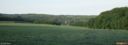
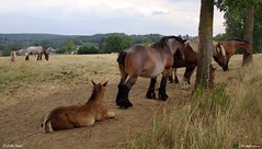
From Ottenburg the trail moves towards the Sint Agatha Rode forest, with some very steep section reaching almost 23% . The track here was also washed out and the loose stones made it a tough climb. But I made it. Technique and strong legs coupled to a good bike and great traction , once again. Following the Overijse trail for a while now and then, generally moving towards Terlanen and then up to Huldenberg via a long sandy climb in a hollow road. A bit further another steep climb awaits me, bringing me to a crest and a path between two meadows from where I have a great view of Huldenberg. Pausing for a while to look at the strong horses I also took a couple of pictures of these marvelous animals.
A very nasty descents with all kinds of stones and other rubble and I'm down in Huldenberg where I can relax a bit while the trail follows the border of the river Ijse towards the Margijsbos. Here a cluster of 4 climbs and descents adds a serious amount of heightmeters to my conto. In the meantime my legs also get conveniently sapped of strength. Down towards the Wolfshagen at last and then up again along the Kleine Keistraat and the Grote Keistraat . The long climb brings me back on the Smeysberg and I follow the Nijvelsebaan for a while towards Huldenberg before taking a sharp left into the Koestraat. Down with great speed towards Sint Agatha Rode now. Crossing the Leuvensebaan and following a track near the river Dyle towards La Marbaise. From here I make my way into the Bois de Beaumont and add a hilly section into Meerdael Forest, following some tracks that are in my Secret Meerdael Loop . Up and down the crest overlooking Nethen until I reach the Kluis and decide to start heading home. The heightmeter on my Garmin nears the figure 1000 and I decide that is quite enough for today. Looping back over the Zoete Waters and Vaalbeek I add some more heightmeters and arrive home with a solid 4 hours' ride under my belt.
Ride Stats : 68K and 1030/1110 heightmeters (Polar/Garmin) in 3h59mins
5744/60455
26-07-2010, 17:43 geschreven door Big Bad Wolf
|
|
|
|
|
| 24-07-2010 |
| Lubbeek Roadbook |

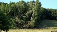
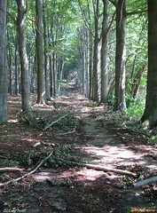
It had been a while since I first rode the O2 Bikers roadbook that starts in Lubbeek. In fact you can read my account of the first encounter here. I rode the Moots over Bierbeek and Korbeek Lo to pick up the trail on the ridge overlooking Korbeek Lo. I used the same version of the track as last year but the Garmin Edge 705 has seen some software since then. Which makes for a better refresh rate after corners and also the version of the topographic map is now in higher contrast and better colors. The first sections to reach Pellenberg are a good intro into what this route offers. A couple of tracks in the forest, a tricky downhill and a very steep ascent on a small singletrail. The trail then worms itself in the direction of Lubbeek. I noticed it must have rained considerably in this region yesterday because the trails looked pretty washed . Also, the storm of July 14th has left a lot of trees decapitated. I passed the section where I flatted last year with some reservation but all went fine today. No flat tyres. I don't hate mending a tyre but stopping also means that horseflies have a chance of finding their way to my body. I wore long trousers - imbibed with my custom insect repellent - and sprayed Autan on my exposed arms. I didn't have any problems with insects, luckily. The weather was sunny but a very noticeable northwesterly wind kept the temperatures in the lower 20ies. Degrees Celcius that is. A fine day for a ride.
When I passed the start in Lubbeek I paused to restart the navigation on my GPS and before long I was enjoying singletracks again. The climb to the Calvarie Berg was very steep and also very difficult due to fallen branches and washouts form yesterdays' thunderstorm. Before crossing the N2 I was hesitating again when the track directed me into what looked to be private property. But I went for it and indeed, it was allright to pass. The Sassenbeek walking route, with the logs still in place, made me wish I had a full suspension bike instead of the YBB but it was only 200 meters long. The trail then moves towards Tielt Winge and follows a local mountainbike trail, called the Solveld route. Great passage in the forest here, with steep uphills and a couple of very fast downhills. I later noticed I clocked 60kph at one time. I was almost tempted to ride this section again but decided to move along the route instead.
The trail now moved along small singletrails through the fields. The wind was playing its part and I was feeling my legs from yesterdays' ride. But nearing Linden another passage in the forest awaited. And a great one. This time I didn't miss part of the loop - although I nearly took a wrong direction again at the point where the track almost converges with itself. I noticed I was wrong and had to backtrack a little. But then I could enjoy a downhill into Linden and a nice long uphill along some winding singletrack in the forest. From Linden the track crosses the N2 again and then follows the GR route up the ridge overlooking Korbeek Lo. Hey, I've come full circle.
Beautiful track, and one of the better O2 roadbooks in my region for sure. You can download the track at the O2 Bikers website. Just search for Lubbeek. Officially its around 40K and has 550 heightmeters. I won't argue with either figure, they are correct. You have to take care in some of the forest passages because there are plenty of trails crisscrossing and the track has not a lot of trackpoints. I could provide a higher quality version of todays' track if needed, just pop me a mail.
Ride Stats : 60K and 730/815 heightmeters (Polar/Garmin) in 3h16mins
5677/59345
24-07-2010, 18:10 geschreven door Big Bad Wolf
|
|
|
|
|
| 23-07-2010 |
| LF6 |
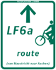
Weather forecast called for possible showers, even an occasional thunderstorm. After having checked meteox.be I decided to take my chances and follow the LF6 Vlaanderen Fietsroute about 40K out. This route takes me through Bierbeek, Meldert, Hoegaarden and then to Laar and Neerwinden. When I was close to Neerlanden and saw 41K and 1h45 on my counter I decided to turn.
Up till now the sun had been my companion but when I turned around I noticed some darker clouds over the far horizons. In Laar I passed some witnesses of the July 14th storm. A lots of trees had been broken and I stopped to take a picture of an old willow.

When I neared Meldert I was sure I would not be able to escape a gathering thunderstorm. I had heard the thunder a couple of times and I could see the dark center cloud on my left. When I left Opvelp it started to rain. I put on my Goretex Paclite and for 3 to 4 K it rained heavily. When I left Bierbeek the rain subsided and the wind already started to dry my clothes. Only a couple of kilometers to go now and I finished with a good ride under my belt at a long distance pace and with an average heartrate of only 109bpm.
Ride Stats : 82k and 535/590 heightmeters (Polar/Garmin) in 2h29mins
5616/58530
23-07-2010, 14:58 geschreven door Big Bad Wolf
|
|
|
|
|
| 19-07-2010 |
| Language Border roadbook |
Today looked like a perfect day for a longer offroad ride. Since temperatures will rise tomorrow and wednesday might see thunderstorms, today was the day. I took the Moots out for a spin around the O2 Bikers 'taalgrens' roadbook. Having ridden this before I knew what I wanted to do. Ride the beginning through Meerdael Forest and Nethen, then in Pietrebais decide whether I should ride further or not, cut through to the returning track and pick it up again in the neighborhood of the Ferme de Wahenge.
I wore a Troy Lee Design Moto enduro trousers over my 3/4th Assos jerseys to keep the horseflies away. This enduro trouser is thicker than normal trousers and is by design very light and airy. I had no troubles with it . It performed like it should and kept all nasties away from my upper legs.
Even though I left at 8.30AM by the time I reached Pietrebais, some 2 hours later, I begann to feel the heat when I was in the open. And there is a lot of open in this ride. The start is nice and cool in the forest, but then it alternates through light and shade in the Nethen fields and hollow roads. A long patch in the fields connecting to Pietrebais where I took a little break in front of the church.
I decided to follow the track to where it crosses the N91 near Happeau. From there I made my way towards the N240, crossing it near Melin. I saw some track on my GPS that turned out to be a non-track and I had to cross a field in order to hook up with the rutty track I wanted to avoid. Still, I then reached the ferme de Wahenge and was on my way again for another hour in the open fields. I was glad I saw Meerdael Forest again and quickly road through I to emerge near Haasrode. A last stretch over tarmac brought me home just past noon. Not bad for a ride in these temperatures and I was glad I met my goal for today.
Ride Stats : 65K and 530/590 heightmeters (Polar/Garmin) in 3h39mins
5474/57535
19-07-2010, 13:40 geschreven door Big Bad Wolf
|
|
|
|
|
| 17-07-2010 |
| Around Leuven |

A pulled muscle in my lower back made me take it easy for a couple of days but today I wanted to see if I could ride again. So I set out , after it had rained a bit in the AM, for an easy recovery ride. Ride which took me through Heverlee and to the Parkpoort in Leuven. I then followed the rind around Leuven , pausing briefly to take a picture of the monument Rik Poot erected in front of the KBC Insurance buildings. It is called 'The Abduction of Europa' and pictures Europa being taken away by Zeus, in the form of a majestic bull.

I then continued along the ring around Leuven until I reached the Naamsepoort. Here I disappeared into the smaller alleys and my road then took me towards Heverlee and Oud-Heverlee. Along the Zoete Waters and further towards Sint Joris Weert and Nethen. From there it was only a small stretch towards Hamme Mille and Meerdael again. I felt Ok throughout the ride and now have to wait how the muscles will react to the strain of the ride.
Ride Stats : 37.5K and 250/290 heightmeters (Polar/Garmin) in 1h40
5355/56555
17-07-2010, 14:27 geschreven door Big Bad Wolf
|
|
|
|
|
| 14-07-2010 |
| Birthday Ride |
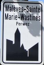
Rise and shine at 7.30am to beat the heat. I was planning to combine the 50K of the 1W Tour des Loups, with the 100K of the BizOnTheBike . Starting out in Pietrebais the 1W moves slowly towards Perwez. The wind was blowing hard from the south - a dry hot wind - and I struggled a bit in the beginning. Not wanting to stress myself too much in view of the lenght of the ride - I guessed it would be between 85 an 90K - I took it easy and tried to enjoy the sun which was already making its way like a speedy fireball towards the zenith.
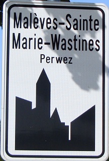
Passing through villages with names like Maleves Sainte Marie Wastinnes I reached the outskirts of Perwez and took the 50K version of the 1W along the ravel towards Ramillies
Then the track turned towards Mont-Saint-Andre and Bomal. A bit further the track then is joined by the 90K 1W trail as it drops into Jauchelette.
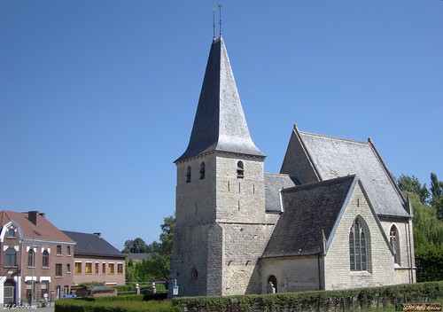
A tough bit is the climb out of Dongelberg, where the sun is hammering on my back. After Dongelberg I reach Lathuy and when I cross the N240 and enter Melin I have to switch from the small 1W signs to the big blue BizOnTheBike arrows. My trail now leads me to Saint Remy Geest and Zetrud Lumay. I pause to take a picture of the Hoegaarden church before entering this village at the edge of the language border.
The trail now makes a loop towards Hauthem and the Marollen Chapel before entering Hoksem where I take a picture of its unique church with the two church roosters.
A long uphill and fast downhill takes me to Kumtich where the track at last turns towards Willebringen, Neervelp and Bierbeek. It turns out my guess was exactly right since the trail measures almost 90K. With a riding time of almost 4 hours I beat the midday sun. When I arrive home some small clouds begin to appear. Perhaps we will see some rain in the afternoon.
Ride Stats : 89K and 680/735 heightmeters (Polar/Garmin) in 3h59mins
5318/56265
14-07-2010, 14:02 geschreven door Big Bad Wolf
|
|
|
|
|
| 12-07-2010 |
| Extra Meerdael Classic |
|
This morning saw the passing of some thinderstorms with only mild rain. So in the afternoon I decided to try my luck offroad and headed out with the Moots towards Pecrot. I had decided on doing the extra loop the 100K meerdael classic did after the split from the 67K distance. I had noticed that this 37K loop had around 700 heightmeters, nearly half of the entire 100K distance. And of course my legs had also noticed the relentless succession of climbs and descents. So after a bit of work with Mapsource I had extracted that loop and loaded it in my Edge 705.
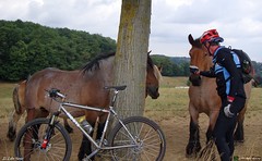
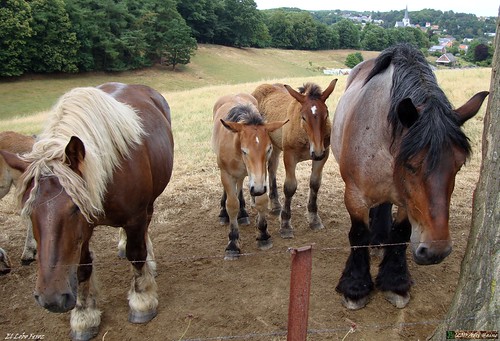
Starting in Pecrot with the infamous railroad singletrack followed by a climb and descent towards Florival station. Then the loop goes towards the Laurensart forest for a great loop followed by a passage through Ottenburg and down along the Oliestraat. 22% climb into St Agatha Rode Bos and then following the Overijse loop for a while before taking a right towards Terlanen and up through the Zandstraat. A first passage on the Smeysberg. The most difficult climb on the Overijse trails is also there, and at the top you have a beautiful lookout over Huldenberg. The Brabanders were there so I paused briefly to take a couple of pictures.
Then a fast downhill through a tricky hollow road into Huldenberg and a bit of recovery along the edge of the river Ijse. Not for long though because the trail then does 4 climbs in the Margijsbos. Yes, an amazing loop this one. Down towards the Langerode and then yet another long climb back up the ridge. At last a downhill towards the Langerode again and a passage through Sint Agatha Rode brings me towards the Marbaise where the trail ends . Amazing loop, and a tough one as well. You can find it on my Garmin Connect page where you also find the complete 100K if you should feel the need to ride that.
But if you only have a limited time I want to recommend this extra trail. It is one of the best loops I've done in a while in this region. There is not much I would add, given the already large amount of hills, descents and curvy singletrails. Be prepared for a 2h30-3 hours ride though.
Ride Stats : 60K and 810/885 heightmeters (Polar/Garmin) in 3h28mins
5228/55530
12-07-2010, 20:28 geschreven door Big Bad Wolf
|
|
|
|
|
| 11-07-2010 |
| Huppaye |
|
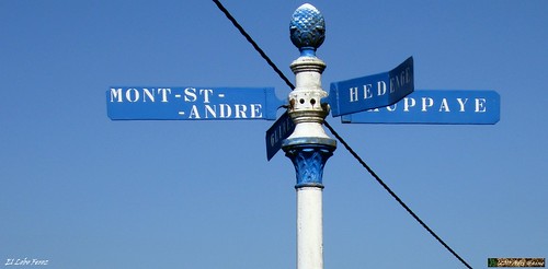
Despite the passing of a few thunderstorms, with some welcome rain, the temperatures were already rising towards 25 degrees C when I rode out a little before 9am. I wanted to do a substantial ride before it got too hot. I rode over Bierbeek and Meldert towards Hauthem and then descended into Hoegaarden. Following the Ravel just past Jodoigne to where it crosses the incoming track of the 1W ride.
This happens in Huppaye. From there I followed the 1W ride over Dongelberg, Lathuy and Melin to the N240. Here I followed that road towards Hamme Mille and then took a left towards Nethen for a last loop over SintJoris Weert and the Zoete Waters. By now it was nearly noon and the temperatures had risen to a comfortable 30 degrees C. Good thing there was a good breeze blowing from the west. When I arrived home I could see the first clouds forming on the southern horizon. More thunderstorms are forecast later today and tonight.
Ride Stats : 67,5K and 425/525 heightmeters (Polar/Garmin) in 2h57mins
5168/54645
11-07-2010, 13:22 geschreven door Big Bad Wolf
|
|
|
|
|
| 08-07-2010 |
| Fighting Falcon |
|
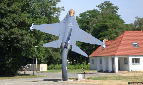
I started an hour earlier today to try and beat the heat but I still had 2 degrees more on average than yesterday. 29 degrees C that is. Good thing there was still a breeze blowing because there was not a cloud in sight to stop the sun from beating down. I did another 'in point' ride, riding out over Hamme Mille and then through the fields along the N91 towards Pietrebais and along the N240 passing the main entrance of the Charles Roman 1W Airbase. I then took a left towards Melin and then crossed the N240 again on my way to Lathuy. In the fields past Lathuy , one hour into the ride, I took a 360 degree turn .
I took the same way back but decided to have a better look at the General Dynamics F16 fighter that was recently put on display on the entrance of the Charles Roman Airbase in Beauvechain. I took a series of pictures that can be viewed HERE. Here is an example.
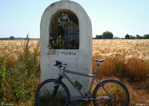
From there I took a turn towards the N240 again and followed my way back home along the same way I had ridden an hour ago. I also stopped by the little chapel outside Nodebais for a brief rest in the shade. I like to read the texts that have been written on its walls.
From Nodebais it was a short way through Hamme Mille and into Meerdael Forest to get home just past noon. It promises to be a very hot day and it really should rain because the fields are so dry the harvest is in danger. Maybe tomorrow some thunderstorms might reach us, but that is not the kind of rain the land needs. It really should rain for a day , soft and continuous. But that is not in the immediate future it seems.
Ride Stats : 48K and 365/465 heightmeters (Polar/Garmin) in 2h12mins
5101/54120
08-07-2010, 13:41 geschreven door Big Bad Wolf
|
|
|
|
|
| 07-07-2010 |
| Notre Dame des Affligés |
|
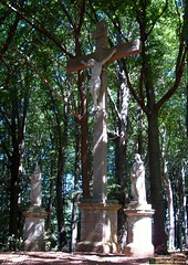
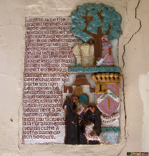
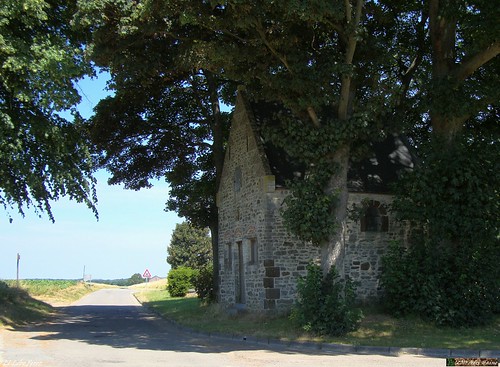
Sun is out, even with a stiff breeze blowing from the south things were heating up very fast. Rode out with no particular idea for a route in my mind. So I started by following some orange arrows that brought me to the Zoete Waters and then to Sint Joris Weert and St Agatha Rode, there I rode towards Terlanen and climbed up to Ottenburg. Here I decided to ride towards Basse-Wavre and connect to Gistoux and Chaumont, following the same route like the Tour de France did 2 days ago. Just past Gistoux I took a left turn and made my way towards Longueville. Here I paused briefly in the shade of the Chapelle du Cheneau, or as it is officially know, the Chapelle Notre-Dame des Affligés.
Riding along towards Heze and Grez Doiceau I felt the ultimate joy in cycling, a slight downhill with a gentle breeze and the sun in your back and overlooking some very beautiful landscapes. From Grez I took the direction of Hamme Mille, passing through Bossut on the way, and then back home.
Ride Stats : 58K and 510/550 heightmeters (Polar/Garmin) in 2h40mins
5053/53655
07-07-2010, 14:59 geschreven door Big Bad Wolf
|
|
|
|
|
|
|
| Gastenboek./.Guestbook |
Druk op onderstaande knop om een berichtje achter te laten in mijn Gastenboek. /
Press the button below to write in my Guestbook.
|
| Email Me |
Press the button to send me a mail
|
|
|
|