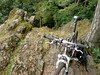
I wanted to ride my complete Secret Meerdael Loop today, so I started out early because I know what a tough ride this is. It's secret so I can't say very much about it, except that the first part consists of mainly small trails and twisting singletracks and yields around 260 heightmeters in about 20K. I took an hour and 22 minutes for that part, so it's by no means easy going. The second part is the really tough one, consisting of a relentless string of small steep hills that takes all the strenght out of your legs. This part is around 45K long and has a whopping 800 heightmeters in it. Not bad for Meerdael forest isn't it? I added a few extra bits and took out some others where the trails were blocked by fallen trees. The tracks were dry-ish in the beginning but during the ride it rained for 3 short periods, making the last bit also very slippery. I was a bit upset because until that last 5K or so, my bike was as good as clean. The last K's made it muddy though because of the top soil being wet . As usual I was swearing and cursing and basically dooming all horses to hell. Horseback riding is very popular these days and the hooves do a lot of damage to the trails. Of course they have their own trails but like most bikers they love to ride their steed also where it is NOT allowed, turning beautiful singletrails into pothole-ridden nightmares. Good thing I was with the Moots but still I could feel all the bumps in my upper torso and arms. Oh well, it's supposed to be a tough ride isn't it.
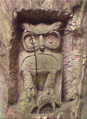
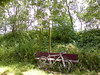
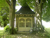
Oh, and I found Ad's Owl. I noticed it during the first part of my ride and obviously I couldn't resist taking a picture of it.
Ride Stats : 62K and 1035 heightmeters in 4h05mins
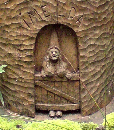
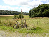
After a days' rest I was eager to get om my bike again. The weather was overcast but it looked like it would remain dry. Didn't feel like riding on the road, instead I took the Moots out for a bit of exploration in and around the Dyleland area. I had read about Ad Wouters sculptures in the Heverleebos and Meerdaelwoud so I wanted to check some of those out - again. I started out into the Heverleebos and rode up to the Arboretum where I saw the first of his sculptures. From there I made my way over to Oud-Heverlee and the Dyleland area. In Korbeek-Dyle I entered the Doode Beemde . This is a wet area surrounding the river Dyle. It was quite manageable despite the rain of the last days. But that rain was often just a few drops of light rain, as it would turn out not enough to really create deep mud. After crossing the Doode Beemde I rode over to Neerijse where I did a nice loop into the Margijsbos.
Until now the ride had been quite flat but now the heightmeters were beginning to add themselves on my Polar and in my legs. Discovered some nice singletracks and then rode over the Smeysberg and into the St Agatha Rode bos. From there I dropped into Eerken and rode up the long hollow road into the Bois de Laurensart. Quick downhill into the field that lies in the middle of this forest and then I took the climb following the Overijse route. Some more exploring towards Gastuche and then straight through the Bois de Laurensart back down towards Florival. Here I climbed the slope towards La Malaise before dropping into Pecrot and back out of it along the railroad and then up into the Bois de Beaumont. From here it wasn't very far to the Meerdaelwoud where I first stopped for a drink at the Hertebron before climbing up towards the Kluis area. I crossed the Naamsesteenweg to have a look at some other Ad Wouters sculptures in the Walendreef. A fine ride and I passed some areas I hadn't been in for a while. The pace was relaxed and I only fell a few raindrops throughout the entire ride.
This morning I had an appointment with my friend Roger to ride the Accro Bike - or parts of it. Unfortunately when Roger arrived at my place it had started raining. I'm not too fond of starting out in the rain plus I still felt tired from yesterdays' ride. So Roger had to ride on his own, since he could not ride in the evening - the weather forecast called for drizzle in the morning and the early afternoon with dryer weather coming in later in the day. After the Tour de France finish I checked Meteox for the current rain forecast and all looked clear. Around 5pm I rode out, very careful to warm up my sore legs. When I arrived in Grez-Doiceau I set on the Accro Bike track in the reverse direction. The rain didn't leave to many puddles, except for some place in the forest. The weather was still overcast so visibility was not high under the leaves either making some parts very dangerous ro ride.
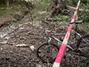
I already had decided to make some detours around a few known 'bad' spots in the course, and I had to walk on some of the downhills. Partly because they were very slippery - my Nokian NBX are great tyres but they reach their limits when it is really slippery clay - but also because some of the trails were so washed out I had to lift the bike over some of the gullies. I also tried out a new alternative for the hill next to the Bercuit golf circuit. This is a private road and it has some gullies that make biking through impossible. When it is dry I have an alternative in the forest but when it has rained that is impossible to ride either because of some deep puddles filling up with water and forcing you to walk around them. So I took another way around which consisted of a tarmac road that turned into a cobble road and then into an offroad track. It doesn't make any difference in height meters so it is a viable alternative. Because of my late starting hour I was anxiously looking at the clock but as it turned out I had more than enough time to make the complete lap. In fact I was very relaxed since my average heartrate was only 108bpm with a maximum of 141bpm on one of the climbs. I never forced it and got on the piccolo very fast to spare my legs. Even then I was glad to see that I almost averaged 18kph and 16kph on the Accro Bike lap itself.
Today I was set to go to Nandrin. A little village a few klicks south-east of Huy where I know this beautiful loop local bikers conceived more than 10 years ago. No-one ever does these loops anymore because the signage is as good as gone and the trail maps cannot be had anymore. Still, I HAVE the trail maps AND the white and red loops are engraved in my memory. The trails are a mixture of forest and field roads, sometimes very rocky, sometimes rooty and always tricky and treacherous. The combination of the two loops yields around 48K and some 800 heightmeters. During my last visits I had noticed some newer signage, Red and Yellow ADEPS signs which might prove interesting to know where they went to. So when I crossed some Green Adeps arrows today I decided to try and follow them to see where they went.
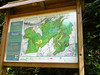
Tavier Intermezzo: I was lucky because after only a few kilometers I was at the starting point of this green route. It turned out to be the little village of Tavier. Together with neighbouring Anthisnes they have set up quite a few walking and cycling routes. The Green turned out to be the most interesting ones - getting 3 on a scale of 3 - and with 17K it looked do-able. So I tried to memorize the first couple of crossroads and set out on that route. I took some pictures of the trail map for future reference. Sadly enough the markings were not very good.
At the first crossroads there was already nothing, except an empty pole where the signage used to hang. Damn ! Deciding it wasn't any use continuing I decided to study the route map at home, and come back when this map had been marked on an IGN map. That way I would have more chances of actually making the whole loop. So the Tavier loop is to be continued on another day.
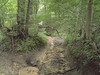
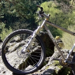
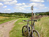
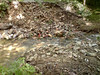
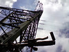
Back to the Nandrin routes: So I had to backtrack the Green route from Tavier to the point where it left the White Nandrin loop and continue on that one. The trails were remarkably dry - the occasional mudhole notwithstanding - and I was taking it easy enjoying the trails and the sunshine. The wind was blowing quite hard on the open spaces and I was glad to be in the forest from time to time. After the interconnection with the Red Nandrin route, just past Soheit-Tinlot, things get really serious. The route drops into Outrelouxhe and then disappears into some kind of crevasse formed by a little river. Here awaits the longest climb of the day. I have discovered that there are actually two tracks going up to the plateau so I usually do both climbs- yes I am a masochist. They put up a new trail map of this area - see the picture DCS00262 - and based on that I might even have another option to do a long steep climb. Another trail that waits to be explored. I take the first climb all the way to the top - it's very steep and very washed out but I make it. I then turn back and ride all the way down again , turning onto tarmac for the approach to the second climb. When I turn left into the forest and arrive at the bridge I normally take towards the other side of the river and the beginning of the long climb I get a big surprise. The bridge is gone, simply washed away during the heavy rainfall a few weeks ago. I have to take another approach and whilst doing the second climb I have all the trouble in the world to make it. There has been a lot of water here, all the sand has washed away between the stones and the rocks and the climb is very steep and now riddled with loose stones and rubble. You cannot make a mistake or you come to a standstill . I have to admit, I had to walk a short section on my second climb. On top I take a little break at the foot of a high voltage pylon before making the singletrack downhill towards the rocky outcrop overlooking Les Rochettes. I take a few pictures there as well.
After that , an overgrown track - and I mean REALLY overgrown , I had to push the bike before me through the nettles and brambles - drops me back into Les Rochettes. From there on the trail only offers 3 more climbs. But they are nasty ones, 2 uphills between barbed-wired fields with overgrown gullies where scattered rocks want to make your bike tilt over and drop you into one of the wires. A lot of grinta, technique and power , is needed here. I am at Scry now and there is only one difficult climb left. Another washed away track makes me dig in deep into my power reservoir but I manage to make it, partly due to the excellent handling of the Moots and the Nokian NBX tyres. The remaining couple of kilometers I hurry back towards Nandrin where I arrive after 61K and just short of 4 hours of biking.
More pictures from earlier rides in Nandrin : CLICK
Ride Stats : 61k and 1090 heightmeters in 3h57mins