The Ride:
The last few days had been dry and the temperature was quite good for october. That made me decide to go to the Ardennes area instead of doing a ride closer to home. Better get some nice Ardennes rides in while the getting is good.
Well, actually Soumagne is not the Ardennes yet, but is on the fringe of an area called the Land of Herve, gently rolling landscape with thorny hedges beaconing green and lush meadows. It looks a bit like a big patched quilt. The climbs are generally very steep and there are lots of rocks in the ground, making traction not always obvious. I had been in this region before, the first time during an LCMT some years ago so I knew what to expect. The area can get very muddy during the winter months and you need some spare inner tyres because of the high probability of a flat due to the thorn hedges.
So 10.45am and I'm at Soumagne. Quite a crowd judging by the full parking lot, but an advantage of starting this late is that there always are some vacant spaces close to the start. Simply because the early starters were already back in. 3.5 for all distances (20. 30 and 40K on offer) and 3 reststops for the 40K. At least we wouldn't die of hunger and thirst. The ride is part of the Challenge Gileppe and Haute Fagnes, which usually delivers very good and tough rides with high standards for arrowing and rest stops.Made a digital picture of the map, always handy to have around in case you get lost. The first K's were easy, some tarmac getting out of the town of Soumagne but gradually the road got smaller and worse until all of a sudden we were on a wet trail strewn with rocks and some muddy patches. Yikes, this was not what I came here fore. I mounted an NBX Lite which is some kind of semi-slick but with very good grip in corners. Luckily there was no more mud to speak of later, but the rocks would remain wet. Even at this hour the morning dew was still present (it IS october after all) so I prepared for some tricky wet downhills and hopefully steep ascents. I was not going to be disappointed on either account. Some nice little technical section; a step here, a rocky descent there , got me into the rhythm quite quickly and I was glad to be here. After some 10K into the ride , the 20K distance split off from the other 2 distances and this meant things were getting more interesting fast. First a steep climb towards Magnée after which we had a long drop into the Fonds de Foret. This was immediately followed by a 3K uphill back towards Foret. The steep bits were REALLY steep and had me cursing a few times that I left my chain on the middle ring, leaving me with a 34/34 combination which really had me grind my teeth at some parts of the uphill. At Foret we got the first rest stop, around 17K into the ride. Rest stop which was well stocked with Isostar or water, cookies and some fruit, and had me drink and eat quite a bit to restore lost forces.
After that we had a nice section of tarmac during which the food could settle into our stomach. We more or less stayed on the plateau until the 30K split from the 40K distance.
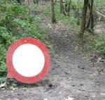
All of a sudden we were on a wonderful singletrack that meandered into a forest. At one point there was a very dangerous turn to the left, just behind a right turn. The track was really bad here and I saw that a lot of people had bailed out here, judging by the tracks going into the rift.. A little 'Danger' sign might have done a lot of good here. We kept on losing height all the way to Nessonvaux, along the way enjoying some beautiful views of the Vesdre valley deep below us. In Nessonvaux the arrowing, which up until now had been really good, was really bad. I had to doubletrack a section because for a while there were no arrows. This is very annoying since you have no comfirmation you are going in the right direction. We passed at least 3 streets were no arrows were indicating whether we should follow the main road, or take the side-street. I followed the main road and after about 600 metres was awarded with an arrow indicating a right turn.
Another long and steep climb took us up on the plateau near Bois d'Olne were I found a 2nd Rest Stop. This one was only for the 40K. and had only water and some assorted sweet stuff. I conversed a bit with the two old-timers which manned the stop, mentioning the dangerous section without warning and the Nessonvaux arrow scarceness. They nodded and asked me what I thought of the region. I had to agree the region was "fantastique" .
And it would remain so for the remainder of the ride, going towards Olne. Leaving Olne we had to drop down again and did so on a track that had steps in it. I was surprised by them so dismounted and ran the first batch with my bike next to me. But I was thinking that the steps were not that bad, only about 20cm high and between 30 and 40 cm long, so I got on my bike and made the remaining drops riding. Care had to be taken because at some points the steps were replaced by wet rock, but then the steps were back again and I could hobble down on them all the way into Vaux-sous-Olne. A great section this one.
Now we were climbing back towards Foret were we had the 3rd rest stop (which was the same as the 1st actually) Some 6 kilometers to go from here but there was a very tricky, and sometimes outright dangerous rocky downhill waiting for us about 1.5 K from the rest stop. Had to keep the concentration up on this one and at one time I bailed out, judging it was not worth taking the risk to try and ride this.
Another steepish climb, at one time I had to walk , too steep and big rocks making it nearly impossible to keep on riding. The last few K's were on tarmac taking us back to Soumagne and the finish.
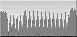
I had 45,7K and 1105 heightmeters on the Polar. That makes for a Hill Factor of 24.
The Lowdown:
What I liked:
+great region
+steep climbs and lots of them
+tricky downhills and lots of them
+nice singletrack sections
+well-stocked rest stops, 1 on the 20K, 2 on the 30K and 3 on the 40K distance.
+fair entry price
+arrowing was sparse but sufficient (except at a few places - see below )
+
What I did not like:
-missing arrows in Nessonvaux and near the end of the ride.
-arrows were paper without support so sometimes bend making it hard to see in which direction the arrow pointed
-wouldn't like to find out what rain would do to said paper arrows
-no danger signs at a few very tricky spots
-sometimes long tarmac sections (500-800 metres ) between trails.
-
no comment on the after-ride facilities (bike-wash, showers, ...) since I did not use them.
Synopsis:
A very good ride, accumulating a fair bit of heightmeters in a great region, well worth the displacement. Tracks were moist and could be hell during rain or after a wet period. Hill Factor is indicative enough, this is a tough ride, due to technicality of both the uphills (steep and sometimes not much traction due to rocks) and the downhills, which were to be taken with full concentration , easy on the front brake .
Entry price of 3 was a steal considering the 3 rest stops. It was the same for all distances though, so 20K or 30K riders might not agree. The region is not as deeply cut as a bit further south, heights varying between 100 and 280 metres, but as you can see on the rides' profile, there were some long climbs anyway. This one is on my list for next year.
There is another ride starting in Soumagne (not the same organisers) which goes towards Banneux and also delivers about the same distance and heightmeters. That ride starts in the St Joseph school while this one started at the local Football field.
The Bare Facts:
map:

Profile of the Ride
A series of pictures taken during this ride
15-10-2006, 00:00 geschreven door Big Bad Wolf
|