|
|
|
| Tales from the Woods |
|
|
| 21-03-2009 |
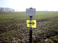
 MTB Orienteering Kesselberg 2009 MTB Orienteering Kesselberg 2009 |

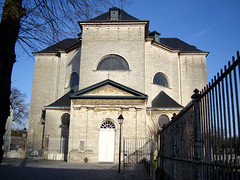
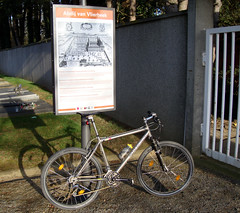
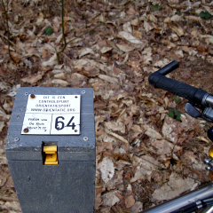
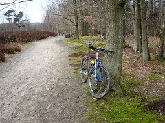
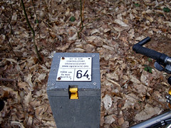
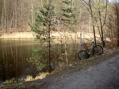
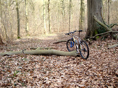
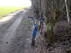
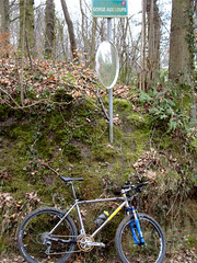
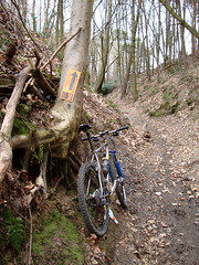
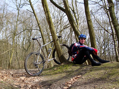
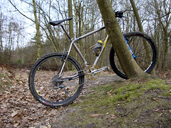
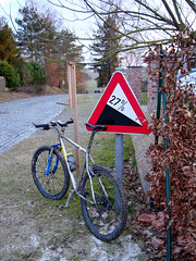
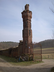
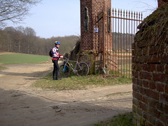
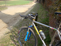
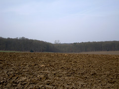
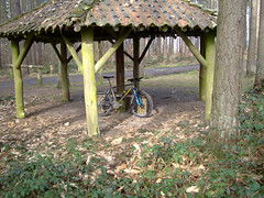
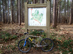
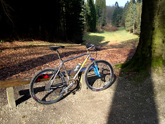
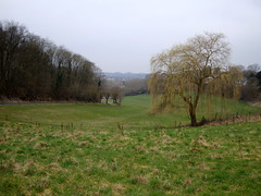
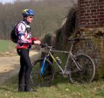
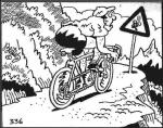
I had received an invitation for this mtb orienteering event from one of the organisers of the SLOK 2009 Kesselberg MTB-O. Since I'm always in for something including my mountainbike and furthermore I also love the region I decided to take part in this race. The SLOK had set out 3 parcours - 10, 15 and 20K - in the hilly region around Kessel Lo and Linden. The start was given at the Abbey of Vlierbeek. Nicely situated in a broad valley just southwest of the Kesselberg area. I rode over from home to arrive around 11am at the 'Rozenkrans' pub where the inscriptions were taken. Since it was my first ever orienteering event I wasn't sure what to expect. But at the inscription I was ably explained the basic rules . You get a map with on it several marked and numbered points. You have to get from one point to the other - choosing your own way - and get a mark at each of the points. For that you receive an EMIT chip. This chip records a timemark when you put it in the trasmitter situated on the marking point. At the end of the race, this information is downloaded from your EMIT chip into a computer and you get your result. The one that completes the complete tour in the shortest time, is the winner. Simple, but as with all things, it isn't as easy as it sounds. After the inscription I followed the markings towards the official start. Here I received my map and the girl explained to me how I should go about putting my EMIT in the marking stations. She already made the first mark so my race was already running when I was still there listening to her explaining me how things worked. I had brought the cardholder I used in the 2000 Coast to Coast Pyrenees so I could put my map there. The EMIT module I could fasten to one of my fingers. At the inscription they asked for my identity card as a guarantee against the EMIT but I wasn't going to leave that behind. So they had to settle for my UCI licence. Looking at the map I got underway and I quickly learned that riding fast AND trying to read a map at the same time wasn't easy. Furthermore I had to refold and turn my map all the time - my card holder is only A4 and the map we got was nearly A3 format. The 'real' orienteering guys had some kind of rototable on their handlebar. So they could turn the map to keep the place where they were going to, on top and in the front. The weather was great, after a cold start the sun shone in truely spring fashion and riding through and around forests was a joy today. In the meantime I had arrived at my first marker and took a few pictures before heading off to the next one. The first couple of markers were relatively easy, but then things got more complicated, with a mixture of big and smaller tracks. You had to find the quickest path, and this was not always the shortest one. The difficulty was that in order to make a good time, you needed to look at the map and make a decision on the trail which you wanted to follow, whilst driving your bike through offroad trails. Sometimes they were easy, but there were also some steep downhills and sections with gullies . Luckily all the tracks were bone-dry. Here lies one of the big challenges of this sport. You obviously need map-reading skills, but you also need fitness and sometimes catlike reactions when your wheel hits a branch at the exact time when you were peering down at your map deciding on your next direction change. When things really got complicated - read, when there were a lot of tracks converging or several forks really close one after the other, I did stop and had a GOOD look at the map. One mistake could set you off in a completely wrong direction. Fortunately I am pretty good a reading a map and I didn't make a single mistake trackwise. Approaching Marker #12 ( see the map ) I chose a dotted line which looked to lead to marker 12 very nicely, but all of a sudden I couldn't see any more trails, so I clambered up a very steep hill. This must have been my lucky day since I arrived on top at the exact location of the marker. While I was there I saw some other riders arriving from a different direction. Obviously I had taken the more difficult - but shorter - path. The section with markers 14 to 17 was also a very nice one, by now I was getting more confident and during the last section I really got under steam. In the end, connecting all the markers took me almost 37K and 2h02 of riding time. I am very happy to have done this, its a combination of several skills and it involves riding a bike in nature. The only pity is that there are not that many MTB-O events around in Belgium. Next year this event will be held in my own Meerdael forest and I will look forward to participate to that. In the meantime I will certainly look out for similar events in Belgium, I had a really good time. Thanks to all the people at SLOK for making this event possible and to Jef Boeckx for bringing it to my attention.
Ride Stats : 61.5K and 570/588 (Polar/Garmin) in 3h11mins
MTB-O Stats : 37K and 408 heightmeters in 2h02mins
MTB-O Official result : 2h19mins52secs on 23280m or 6mins/km
MTB-O Map
Garmin Map:

Organisers blog : CLICK
Official results : CLICK
1929/16075
21-03-2009, 18:30 geschreven door Big Bad Wolf
|
|
|
|
|
| 19-03-2009 |
| Frisky |
|
Another sunny and dry day. Great. But there was a nasty wind blowing from northeasterly quarters. I wanted to do a ride so I set out towards Brabant Walloon. When the sun was in my face and the wind in my back it felt good to be out. I made a loop going towards Pecrot , Florival and Archennes. Then further towards Dion le Val and Wavre. Some nasty climbing here and when I made my way out of Basse Wavre I began to feel the wind a bit more. Up towards Ottenburg and then down into Terlanen again to take advantage of the sheltered valley towards Sint Agatha Rode. From there I rode towards Sint Joris Weert and the Zoete Waters. Turning towards the East the last bit was difficult but my heartrate stayed low .
Ride Stats : 48K and 385/404 heightmeters in 2h12mins
1867/15505
19-03-2009, 18:45 geschreven door Big Bad Wolf
|
|
|
|
|
| 18-03-2009 |
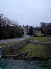
| Vlierbeek |
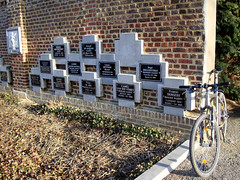
Wanted to check out how to get to the Abdij of Vlierbeek from my place so I biked over there over Heverlee and Kessel Lo. Did not find the place where the start of the MTB-O will be, the Rozenkrans pub, but I had a look around the abbey grounds and made some pictures. I could see the Kesselse bergen and the Chartreuzebos looming over me when I rode over to Linden to make my wat back to Korbeek Lo. Seeing that the weather was fine I added another loop over Bierbeek, Opvelp, Beauvechain and Tourinnes before returning over Hamme Mille and Meerdael. The sun was shining overtime today and even though there was a northerly wind blowing, I recorded an average temperature of 12 degrees C. In the sun and out of the wind it was simply wonderful to be.I did some research on MTB-O in the meanwhile and it is becoming clear that this might be quite a challenge. But since it will be my first time, my only goal will be to find all the control points and generally finish the ride. I have the idea they don't allow GPS so I will put mine in my backpack . I can't imagine riding without it recording the ride, so if they make a problem out of that I will simply not start. I need to familiarize myself with the card and compass way of going from point A to B but I already found some good explanations on some of the MTB-O sites around the world.Ride Stats : 46K and 285/295 heightmeters (Polar/Garmin) in 2h2mins1819/15120
18-03-2009, 19:45 geschreven door Big Bad Wolf
|
|
|
|
|
| 16-03-2009 |
| Bling |
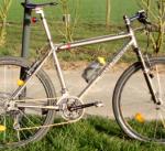
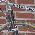
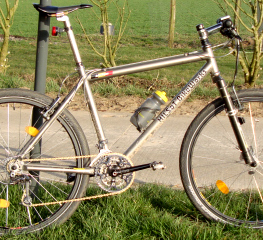
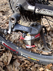
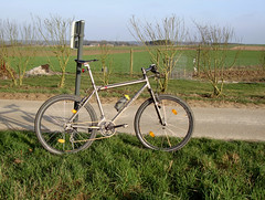
Got a new chain delivered today. It is a golden KMC X9 SL Titanium Nitride coated chain, I already had one like this as a first mount on the Hilset and my last chain was also a KMC X9 TiNi chain, but no SL. Its a good chain, the SL chain even rolls a bit more quiet than the normal version and it is also very light. Perfect for the use I'm making of this bike. The chain has a Titanium Nitride coating which makes it a bit harder to wear. The Missing Link is a re-usable connector , along the same principle as the SRAM Gold Link. Obviously the chain looks well on the bike, especially when its new. I also changed the jockey wheels on the XTR rear derailleur. They were still the first ones and it was time they got changed since I had this bike - end of May 2005 - so thats nearly 4 years. The teeth were almost resembling shark teeth. I changed them for XTR 11T jockeys.
If all goes well I am thinking of entering an MTB-O event next saturday. Its held in nearby Kessel-lo so finding my way around should not be too hard. Of course I will need to learn how its done the hard way, but I'm pretty confident I will find my way. Its a competition but I'm not counting on riding fast , just having a good time combining mountainbiking and orienteering. Should be fun. Lets hope the weather stays dry. Today I just did a quick ride around Heverlee, Bertem, Neerijse , Sint Agatha Rode and Sint Joris Weert, finishing with a loop taking me past the Zoete Waters to Oud-Heverlee and Heverlee again. The weather was nice with 11 degrees C and nearly no wind. It got a bit frisky by the time I finished my ride but I was home before dusk.Ride Stats : 40K and 270/269 heightmeters (Polar/Garmin) in 1h41mins1773/14835
16-03-2009, 19:17 geschreven door Big Bad Wolf
|
|
|
|
|
| 15-03-2009 |
| Solitary Orientation Run |

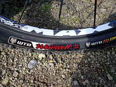
The weather forecast was wrong! When I got out of bed at 10AM the sun was shining, no trace of the forecast rain. Obviously it was too late to enlist for any organised ride but I quickly discovered I would be far better off doing one of my orientation runs. Since I have a GPS and with my inborn wanderlust this is one of my favorite passtimes when on a bike. I have a broad idea of what I want to do and I just add some tracks and trails along that idea as I move along. Starting out into Meerdael I quickly was mingling with riders on the SVK organised ride. I also quickly got a reminder as to why I don't like starting on organised rides outside of the Ardennes area. Some riders think they are racing and they don't mind cutting you off when passing. I had to smother a shout when some jerk nearly tipped my front wheel - he would have if I had not braked - when passing me. A bit further I passed him again but I managed to keep myself under control. A bit further I left the flock and continued on my solitary route. My plan consisted of riding towards the Margijsbos. For now I was descending into Nethen and ascending again in the direction of Pecrot. From Pecrot I dropped into Florival, after having done an extra climb along a tricky track, steep and slippery at times. I had to put the chain on the small ring to make it. Obviously yesterdays' ride was still in my legs so I selected the small chainring a lot. This offered my legs the opportunity to relax a bit during the climbs. I then climbed up into the Bois de Laurensart - in the opposite direction of the Overijse BLOSO route. I encountered a couple of bikers going downhill in the deep hollow road but they had their bikes nicely under control. In these situations the biker going uphill has right of way. Arriving at the top I dropped down again to the lawn, a big lawn between two patches of forests, and struggled upwards again into Ottenburg. I did a quick loop up and down the Tomme and then set course for the Sint Agatha Rode forest. Tackling the steepest climb into that forest - the singletrail leading upwards from the Neerpoortenstraat - I conquered the 21% slope without any problem. I had to balance my weight very carefully on this very steep trail but my Weirwolf tyres found plenty of grip on the gravelly trail.
I then descended towards the Vossekouter in Terlanen and had to conquer another 20% trail to reach the top of the Smeysberg. Down on the tarmac and then I took the path alongside the river Ijse towards the Margijsbos. A couple of nice singletracks here to make it up and down the slope a couple of times. I encountered some riders on the SVK organised ride again. They must have been the last ones on one of the longer distances, judging by their struggling on the uphills. I tackled the Bertelsheide and immediately dropped down the hollow road on the left when I reached the top. Right at the bottom and I was back on the Nijvelsebaan. Not for long because I took a left plunging down towards the Wolfshagen and further towards Sint Joris Weert. Here I added another loop into the Meerdael forest. Up into the Borrestraat and towards the Kluis, before descending towards La Hetraie after which I climbed upwards on one of the nicest and most difficult climbs in Meerdael forest. Down again towards the Kluis along the trail the Meerdael BLOSO track follows - but in the opposite direction and then back up after passing the ponds near the Kluis. I then followed a small track to arrive at the Kleine Dreef. This I followed towards the Grezse Baan. Left towards the Weertsedreef and left again on the Weertse Dreef. Right onto the Nethensebaan and following this towards the Groenveld I made a quick loop towards Vaalbeek before calling it a day and looping back towards Blanden. A great ride, the tracks were moist at places but certainly not wet. With 725 heightmeters I can not complain and I had a good feeling in my legs throughout the entire ride. With an average heartrate of 121bpm I certainly did not overdo it .
Ride Stats : 45.5K and 725/773 heightmeters (Polar/Garmin) in 3h30mins
Map : 1733/14565 1733/14565
15-03-2009, 17:33 geschreven door Big Bad Wolf
|
|
|
|
|
| 14-03-2009 |
| Roumirette and Aeolius |
I had a spot of trouble, some saddle soreness had taken hold, and I decided to stay onroad and see how it would go. The weather was fine when I rode out , around 11am , it was warm but there was quite a bit of wind. I decided to wear an 3/4 Assos Roubaix trousers and also wear a long sleeved jersey and a bodywarmer instead of the thermal vest I wore up till now. I'm glad I decided to don the bodywarmer because the wind was indeed blowing very strong on the higher plateaus and with the sun disappearing more and more during the ride the chill factor made it a lot colder than the 12-13 degrees C it was. In Bierbeek I picked up on the old Ludo Dierckxsens track. Turning clockwise in a big loop towards Beauvechain and La Bruyere I started to feel the wind more and more. The high plateaus between Pietrebais and Sart Risbart had me suffer. I was glad that the twisty road provided from time to time a bit of sidewind, or even wind in the back, because it was also mainly uphill until I reached Gistoux. There I turned to the North and things were looking better wind-wise. I included a little climb into the Rue du Moulin d'Inchebroux, with an 18% section only to make an 180 degree turn at the top, eat a banana and enjoy the overview over Chaumont Gistoux. The track than lead me towards Bonlez where I had to tackle another steep climb leading towards the 'Chemin de Tout-Vent' - whats in a name - and then crosse the Wavre-Perwez road. A quick descent into Dion Le Mont and then back along the N243 for a bit before turning to the right towards Dion Valmont and Doiceau. Archennes and Florival followed and upon riding towards Ottenburg I decided to incorporate a bit of extra climbs. So I rode up the Wijmingenstraat, down the Bergstraat and then continued along the Florivalstraat all the way to Ottenburg. Turning left into the Tommestraat and left again down the Langeheidestraat to reach the Florivalstraat again. I then turned left into the Veeweidestraat and a bit further left again into the Burgemeesterstraat for another climb. It has started to drizzle by now so I decided to make my way over Sint Agatha Rode towards Sint Joris Weert. Here I did again a couple of extra climbs.Up into the Polderstraat, turn left into the Oude Nethense baan and down the Speelbergstraat. Right and upwards in the Hollestraat, left into the Oude Nethensebaan again only to drop down along the Heidestraat towards the Leuvensebaan. A last climb back up along the Kasteelstraat towards the Oude Nethensebaan again and then I followed that down towards the Leuvensebaan again. The drizzle had turned into light rain now so I decided to call it a day and return to Blanden alongside the Zoete Waters. In all a very nice ride, and in view of the forecast rain for tonight and tomorrow at least a certainty. For tomorrow I'm not sure what to do. I would have loved to do the excellent SVK 24e Vriendentocht but with the forecast and the wet offroad conditions I think I will give it a pass. Ultimately I will decide tomorrow morning.
Ride Stats : 76K and 705/689 heightmeters (Polar/Garmin) in 3h32mins1688/13840
14-03-2009, 17:40 geschreven door Big Bad Wolf
|
|
|
|
|
| 08-03-2009 |
| Recovery ride |
|
Rain and wind in the AM so I was patient and waiting until the predicted sunny spells would appear. And indeed, around 1PM the skies cleared out and only the wind remained. Streets dried up quickly - I didn't rain that much - and I set out around 2PM for an easy recovery ride. I felt better than I expected but still I stuck to my plan, ride at a low pace and avoid hills as much as possible.
Ride Stats : 26K and 190/171 heightmeters (Polar/Garmin) in 1h17mins
1521/12450
08-03-2009, 16:01 geschreven door Big Bad Wolf
|
|
|
|
|
| 07-03-2009 |
| Accro Bike 54K and then some |

Dry but overcast this morning. I set out with the Litespeed for a first attempt at a 1000+ heightmeter ride this year. I chose to do the 54K version of the Accro Bike, a ride starting in Grez-Doiceau and normally good for around 800 heightmeters. Riding very relaxed towards Grez Doiceau already yielded me 12K and 100 heightmeters. The advantage - but it can also be a disadvantage at times - of knowing these trails by heart and also knowing a lot of other trails in the neighborhood, is that you can combine the path of the chosen ride - the Accro Bike - with some extra trails. Obviously, in a region that is comprised of deep valleys this leads sometimes to more climbing and descending than you have bargained for. I managed to stay on the trail until I reached Cocrou. From Cocrou there is a steep climbing leading into a stretch of forest - I had 23% on the Garmin at one point - and then the trail normally stays on the ridge with Pietrebais on the left. But I veered to the left and down into Pietrebais only to climb out of it again to rejoin the trail. Hopsa, an extra 50 heightmeters. The trail then goes towards the Chapel in Longueville where it turns to the right in the direction of Heze. Here it joins the 42K version of the Accro Bike. A bit further I added another extra descend/climb into the Gorge du Loup - the Wolves Throat - which yielded me another 50 extra heightmeters. But after that I decided to stay on the track. My legs were beginning to make themselves feel and I wasn't even half way. Some good stuff into Chaumont Gistoux and I took a break on top of the first 'impossible' climb. I made it, the track was steep but offered very good traction. I made some pictures, had a bite to eat and set forth on the remainder of the trail.I had been noticing markings indicating 'Challenge du Brabant Wallon' and I was wondering what that was and when it was going to pass here. Might have already taken place. In this part of Brabant Walloon they are not very strict in imposing removal rules for markings of organised rides. If you place a marker in the Flemish part of Brabant, you need to remove it within 24 hours after the event, otherwise they may refuse you passage the next year. In Brabant Walloon I stumbled upon the markings of the Archennes ride "Boucle des 5 Rivieres' which took place last sunday. If I chose to I could have done the entire ride, I am pretty sure none of the markings have been removed -yet. Oh I did do an extra loop coming out of the Bois de Chaumont and riding up towards Aftia. An extra climb - obviously - and then the trail took me down again towards the river 'Le Train' and back up and down towards Bonlez. My legs felt refreshed after the break but they began to make themselves feel again. The Accro Bike is a relentless succession of climbs and descents, very tough and demanding a high level of concentration. The downhill next to the Golf Course in Bercuit was too steep and too tricky so I walked a few metres. A long climb followed up to the 2 Chapels in the Bois des Neulettes. This is Wavre and also the furthest west the trail will go. Under the N 25 and again another 'impossible climb' in the Bois du Tour. Which again I was able to ride completely - with an audience of 3 Enduro Bikers who waited patiently until I cleared the narrow and steep gully. Thanks guys ! back under the N25 through a tunnel and then, instead of going all the way down into Dion Le Val, I turned a sharp left back towards the N25 for another climb. Just before reaching the N25 again, I took a right and descended along a nice singletrack that lead to a field road leading into Dion Le Val. Now I only needed to clear 2 more climbs. Just before entering Grez Doiceau again I passed the 1000 heightmeter mark on my Garmin. I later checked and it seems this version of the Accro Bike 54 lasted 56K and yielded me 900 heightmeters. Not bad. The ride back home was tough, because my legs and lower back were really tired now and I still had to clear two tough climbs. The first one out of Archennes towards Bossut. I took the sandy trail, very difficult but again somehow I managed to complete the whole climb. Dropping into Nethen after that I had another steep climb - this one on tarmac - waiting to take me towards La Trace and into the Meerdael Forest. There I took the Kromme Dreef towards the Prosperdreef which I followed all the way back into Blanden. In all I had a very rewarding but very tough ride. I was pleased to see my average speed was nearly 17kph with an average heartrate of 133bpm. The forecast for tomorrow looks rainy so I am glad I did this ride today. For those who want to give the Accro Bike 56K a try, I uploaded todays gos track to Motionbased.Ride Stats : 81K and 1170/1181 heightmeters (Polar/Garmin) in 4h48minsGPS track of the Accro Bike section on Motionbased : CLICK1496/12260
07-03-2009, 18:14 geschreven door Big Bad Wolf
|
|
|
|
|
| 05-03-2009 |
| Softly climbing |

Dry evening so I went out for a ride on the road. Started out over Egenhoven , Bertem and Leefdaal. There was a nasty northwester blowing and even though it was 8 degrees C it felt cold, especially on the plateaus. I was incorporating a bit of climbing into my long slow distance ride to spice things up a bit. Out of Leefdaal and then all the way to Duisburg and Eizer. I spotted an 18% climbing sign on my left so I had to check it out. Turned out to be a 20% climb so I had to dig deep with my 12-23 cassette in the back. This road led me towards a dirtroad which dropped me nicely into Huldenberg. Here I had to climb the inevitable Smeyberg - I chose the long climb, not the steep one - and then I could thunder down into Terlanen. Another long climb led me towards Ottenburg and from there I rode towards Pecrot where another couple of steeps climbs upped my heighmeter count considerably. In all I had a fine ride, with an average heartrate of 119 bpm which made it sound as if it was a breeze. Well, apart from the climbs it was. I did not force the issue during the climbing, concentrating on a supple rhythm except for the 20% thing where I had to switch into power mode just to make it. 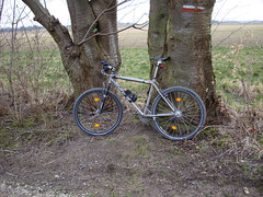 Ride Stats : 55.5K and 535/570 heightmeters (Polar/Garmin) in 2h29mins1415/11090 Ride Stats : 55.5K and 535/570 heightmeters (Polar/Garmin) in 2h29mins1415/11090
05-03-2009, 19:44 geschreven door Big Bad Wolf
|
|
|
|
|
| 04-03-2009 |
| recovery |
|
A very easy and relaxed ride to get rid of the tiredness in my legs. Felt better after the ride, which is always a sign it has done its work. Another chapter in my Templar book and Life singing its V album on my MP3 player. Outside there was a hint of rain and a lot of wind but otherwise not too cold, with temps of around 8-9 degrees C.
Ride Stats : 10.5K in 30mins
1359/10555
04-03-2009, 17:11 geschreven door Big Bad Wolf
|
|
|
|
|
| 03-03-2009 |
| 3 Overijse Bloso's and something extra |

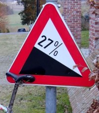
Another dry day, so I left early at work to be able to do my intended ride. Ride up to St Agatha Rode and pick in on the Overijse 2 Valleien Bloso routes. I usually do some extra climbing when I'm doing these, and today was no exception. For those who never rode the Overijse Bloso, I can really recommend them. A good mixture of hills, descents and flat sections. Some of the hills are pretty steep and there are a couple of descents where you better keep your eyes open, they are steep and with some nasty surprises in the form of ruts, gulleys or rooty steps. All the hills were perfectly ride-able today. The condition of the trails was perfect. I incorporated a couple of extra climbs around Ottenburg and finished off with a bit of fun in Sint Agatha Rode Bos. I lost my way - or should I say the trail, and had to descent through the forest. The steepness was 24% which is quite a lot in the loose rubble of leaves, branches and other roots. But I made it down to the trail and could continue for a couple of extra climbs on tarmac. The 27% Nieuwe Laan is only around 20% but I descended that one, having taken the parralel climb coming out of the forest from Tombeek. My legs felt good today and I had a good workout, arriving home after a last couple of trails in Meerdael Forest just when dusk was setting in. The bike was fine but the WTB Weirwolf tyres felt a bit over-inflated, especially on some of the cobbles sections. But I left them because I didn't want to risk a flat tyre with the night closing in. I even managed to make some pictures along the way. Pity the forecast for the next days seems to be calling for rain and colder temps. I already saw some Easter flowers pushing through in a secluded berm, basking in the sun and out of the wind. Ride Stats : 56K and 820/805 heightmeters (Polar/Garmin) in 3h20mins1349/10555
03-03-2009, 20:33 geschreven door Big Bad Wolf
|
|
|
|
|
| 01-03-2009 |
| 3 Bloso's Meerdael |
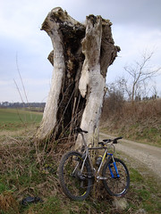
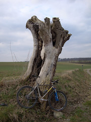
Another beautiful day and even though my legs were tired from yesterdays' ride I didn't want to stay indoors. So I chose to do the 3 Meerdael BLOSO's one more time. The forest roads were rather surprisingly dryer than I expected and I could make good speed. I circumvened 3 notorious mud holes (next to the E-40 , the singletrack leading down to the tunnel under the E-40 and the track on the Red that runs parallel to the Naamsesteenweg) but the rest of the trail was moist but not wet. Lots of heavy machinery at work in the Nethen area which made some of the downhills a bit trickier than usual. When I stopped next to the Savenel walls I saw some bikers who must have been following the organized ride starting in Archennes. In retrospect I might as well have done that one but I suspect that my legs would have suffered a lot more on the many uphills that ride offers. For now it was just enough with a bit more than 500 heightmeters. I also noticed - for the first time - how tall the Dikke Eik really is. Someone mentioned to me a while back you could see it standing out amidst its peers when you pass along the Hamme Mille fields, just before the Ferme des Biches. I took a picture of it and there is another one, taken during the summer, on this website. I had a good week, with 262K and 1725 heightmeters and - according to my Polar - 8000 burnt kilocalories.Ride Stats : 57K and 535/562 heightmeters in 3h1292/9735
01-03-2009, 18:25 geschreven door Big Bad Wolf
|
|
|
|
|
| 28-02-2009 |
| 3 Forest Ride |
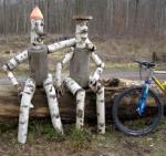
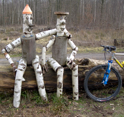
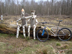
Felt like doing a big ride today. The weather forecast looked good - dry with a hint of sun , no wind and temps going over 10 degrees C. The Litespeed Obed was my chosen weapon for today. I started out through Meerdael Forest towards the Zoete Waters and further on to Korbeek Dyle. There I climbed up the ridge looking out over Bertem and made my way towards Leefdaal and Duisburg. In Duisburg I entered the Sonian Forest, and the next 15K or so would see me ride towards the Middenhut and the Zonienwoudlaan in Rode St Genesse. My first stop here to make a picture of the two wooden folk sitting on a bench. I would have liked to sit myself next to them but I couldn't find a suitable spot to put my camera to make that picture. Next time I must ask one of the passer-bys to make that picture. The weather was - as promised - very clement as I rode the Zonienwoudlaan towards Dworp. Here I made my way towards the outskirts of the Hallerbos. I entered this forest an made a big loop through it. But first time for a little snack at a hide-out and some more pics.
I now made my way towards the other side of the forest, coming back alongside Colipain. Then I rode out of the forest on the road parallel to it, to drop down over the cobbles from hell alongside the Zevenbronnen Castle wall. These cobbles must be ridden to believe how bad a road can be. Luckily in this direction its downhill but they still are dangerous enough to trip the unexpecting biker off of his bike. Care must be taken, especially where to touch the brakes. Next to the Sept Fontaines lakes and I was back on my way upwards towards Dworp and Sint Genesius Rode. On my way back I made an extra loop into the Sonian Forest - forever thanks to Moster Blonde who taught me all these little loops - towards the 3 Fontaines. There I chose to ride alongside the busy highway towards Jezus-Eik. Here I could enter the forest again, along the Kapucijnendreef where I had a second rest stop to have a little snack and, you guessed it, make a couple of pictures.
After Duisburg I made a little extra loop over Leefdaal - adding a climb - and then made my way back over the small tarmac roads towards Korbeek Dyle. I had a good ride and I felt very strong throughout the entire ride. The two snacks must have helped. I would have liked to do some more tracks in Hallerbos but the forest itself was still very wet, and there were a lot of forestry works with fallen timber and big gullies from the machines. The roads in the Sonian Forest were a lot more rideable, as usual, but not entirely dry yet. Still, dry enough for me.
When I arrived home I was very glad to have done my first 90k+, 4h+ ride of the year.Ride Stats : 93K and 775/785 heightmeters in 4h21mins
1236/9200
28-02-2009, 00:00 geschreven door Big Bad Wolf
|
|
|
|
|
| 27-02-2009 |
| More recovery |
|
Took a day off from work today but sadly the weather let me down. Light rain and drizzle, nothing much left but to haul my ass up the rollers and do a recovery ride. Read some more on the demise of the Templars and listened to Rammstein on the MP3 player. By the time I got off the rollers things looked like they were drying out. OK, so maybe tomorrow a long one. In any case todays' ride has not left me robbed of a lot of energy.
Ride Stats : 22K in 1h
1143/8425
27-02-2009, 14:59 geschreven door Big Bad Wolf
|
|
|
|
|
| 25-02-2009 |
| Active Recovery |
|
An hours ride on the rollers, warming up for 10K and then riding around 29kph for the rest of the hour. Legs felt a bit tired but the ride went fine nevertheless. Had a medley of Rammstein running on the MP3 player which got me through the hour rather nicely.
Ride Stats : 26K in 1h01mins
1121/8425
25-02-2009, 18:56 geschreven door Big Bad Wolf
|
|
|
|
|
| 24-02-2009 |
| Smeysberg |
This evening I wanted to ride to the Smeysberg. Initially to see how fast I could ride on the downhill. At work we had a discussion about top speeds on a bike and I know that on a good day with no wind and with with fast tyres I could get 75-80kph on the 17% downhill into Huldenberg. So I set out to see how fast it would go today. Obviously since I was there I took advantage to make it a good climbing training. I rode up every side of the hill and then some other climbs in nearby Neerijse to put the icing on the cake. According to my Polar my top speed on the first of two downhills was 70.5kph, according to my Cateye the top speed was 73kph and according to the Garmin Edge 705 I got 67kph on the first pass and 68kph on the second downhill. I am inclined to believe the Garmin. The Garmin also indicated that the climb gradient of the road parallel to the Smeysberg is 17%, what I am inclined to believe as well. I then rode towards Neerijse where I added a couple of extra climbs before returning over SInt Joris Weert and Zoete Waters. I had my Lumicycle HID light again on the bike , light which has a new bulb and shines as bright as ever. I included a picture of the dreaded Smeysberg, seen from the Sint-Jan-Bergse Steenweg in Huldenberg. The fact that you see it lying in a straight line before you like that is enough to grab your chest tight if you have to tackle it by bike from this side. The steepest bit is a 17 degree angle and it climbs from 35 metres at the bottom towards 95 metres at the top in about 1 kilometer.
Ride Stats : 40K and 415/432 heightmeters in 1h47mins
1095/8425
24-02-2009, 20:10 geschreven door Big Bad Wolf
|
|
|
|
|
| 22-02-2009 |
| recovery |
|
Today I only felt like doing an easy recovery session on the rollers, flush out the legs so to speak. With Rainbow and Nightwish on my MPS3 player and a good book about the demise of the Templars in the 14th century time passed quickly. Outside it was raining.
Ride Stats : 15K in 41mins
1030/8010
22-02-2009, 17:58 geschreven door Big Bad Wolf
|
|
|
|
|
|
|
| Gastenboek./.Guestbook |
Druk op onderstaande knop om een berichtje achter te laten in mijn Gastenboek. /
Press the button below to write in my Guestbook.
|
| Email Me |
Press the button to send me a mail
|
|
|
|