|
|
|
| Tales from the Woods |
|
|
| 06-06-2012 |
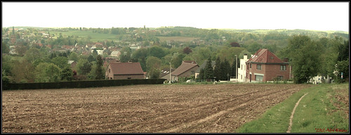
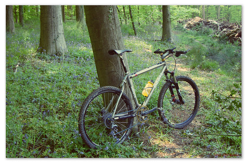
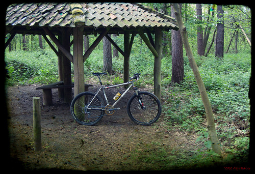
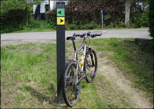
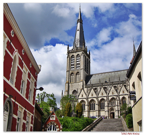
 Rolling in Blanden and Haasrode Rolling in Blanden and Haasrode |
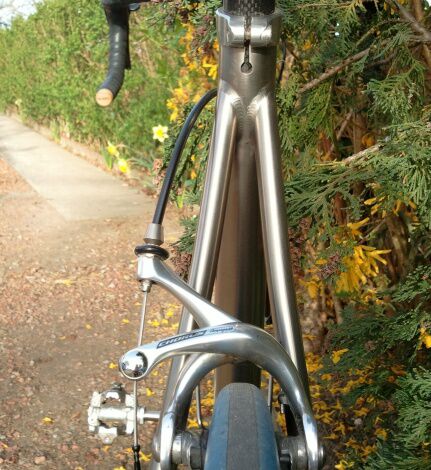
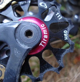
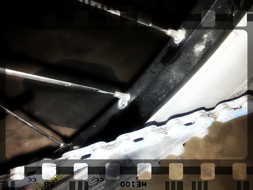
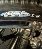
Today saw me riding the Litespeed Vortex with the new Stans Alpha 340 / Sapim CX Ray / Chris King R45 ceramic wheels. They are very light with weight just a tad lighter than that of my Campagnolo Hyperon 2 Ultra tubular set. The Campy's weigh 912g and 1333g front/rear with a Campagnolo Record 13-29 cassette in the back. The new set weighs 929g in the front and 1285g in the back with a Campagnolo Record 12-23 cassette.
The ride is as expected very sweet. The ceramic bearing roll very smooth and there is no tyre rub on the brakes whilst sprinting. Obviously the Chris King hubs need to settle and break in. Due to the extreme tolerances this can take a couple of 100 kilometers. The typical 'angry bee' sound is also not present. It sounds more muffled now. This will changes when the kilometers accumulate.
I felt really good, supercompensating from the Provence weekend no doubt - and did a couple of short laps in Blanden and Haasrode. Just to get a feel for the wheels and check out the gearing . Here are a couple of pictures from the new wheels.
Ride Stats : 19K and 180 heightmeters (Garmin) in 40mins
4081/45495
06-06-2012, 23:06 geschreven door Big Bad Wolf
|
|
|
|
|
| 31-05-2012 |
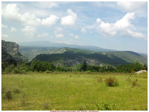
| Expedition Mont Ventoux |
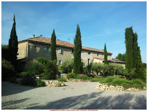
On thursday May 31st I left with the Cellule de Loisir of the Blancs Gilets cycling club to Crillon-le-Brave near Bedoin. After a relatively easy and traffic-free 950K we arrived in Carpentras.
Settling in in the La Condamine , we decided to go out for a ride, a little 'mise en jambes' to let our legs recover from the 10-hour car ride.
Thursday May 31st:
We left our chambre d'hotes and after a couple of K arrived in Bedoin. We rode on in the direction of Malaucene. Climbing up to the top of the Col de la Madeleine. I enjoyed to smooth ride the Vortex with its tubular wheels offered. Compared to the others the wheels also allowed a faster freewheeling speed, du to the Cult Ceramic bearings.
The asphalte was smooth and the 6-7 percentage of the Col didn't offer too much resistance. One half hour into the ride, we turned around and rode back through Bedoin. Later that evening we returned by car for a good dinner in one of the restaurants.
Endomondo track
Ride Stats : 23K and 305 heightmeters (Garmin) in 54mins
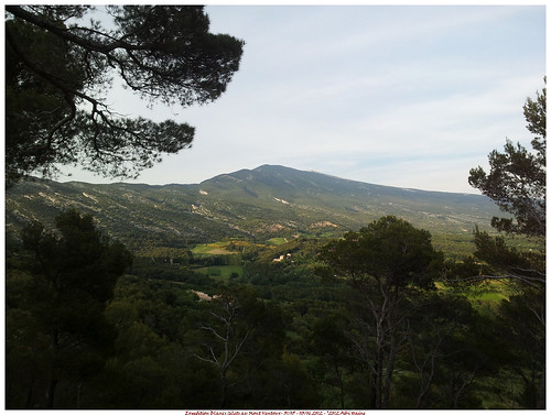
Friday June 1st : The Mont Ventoux.
After a good night's sleep I was ready for the big ascent. We would climb the Mont Ventoux from Bedoin. This meant an average slope of 7.5% over 21.5K. Not something to be scoffed at.
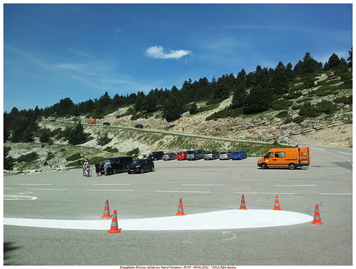
The temperature was already rising to 25 degrees when we rode out at 10AM. First descending into Bedoin and then taking the D974 out . After 2K we follow the D974 to the left where it splits off from the D19. Up to the Saint Esteve corner the slope is easy with around 4-5 %. At the Saint-Esteve the real Mont Ventoux climb begins. The slope goes to 9-10% and will be averaging that for the next 9.5K through the forest. I quickly settled on a pace and the chain went to the 34/29 combination. The forest was hellish. Hot with temperatures now flirting with 30 degrees C and the steep road, the steep road. Spots were the road reaches 12 and 13 % are common. The inside of the curves goes up to 17%.
Kilometers looked that they never would end. The mental game was starting. "I won't make it, lets try for Chalet Reynard and then turn back". But as the kilometers went on I got more confident. Keeping a pace comes easy to me, and around one hour into the climb I reached the Chalet. Here I could stock on water and have a first look at the rest of the climb. The dreaded moon-like wilderness of white stone and an asphalte ribbon making its way up to the naked crest of the mountain.

CC
The climb eased out just a little for the first 2K out of the Chalet. But another adversary was rearing its head. The wind which blew from the right over the crest. Each time the road veered into it, it felt as if a giant hand was slapping in your face. Once I was 'en danseuse' , standing upright on the bike, and was nearly topped over by a sudden gust. I decided very quickly to remain seated for the next of the climb. Pausing at the Tom Simpson memorial plaque around one K from the top brought a little relieve. But the last K must be the toughest of them all. Nearing a 9.5% average and with the wind blowing full force over the Col des Tempetes. But all things come to an end and with a big sigh of relieve and really proud of my achievement I reached the top. 1912 meters after a 1600m ascent.
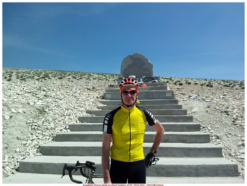

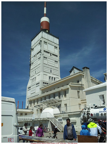
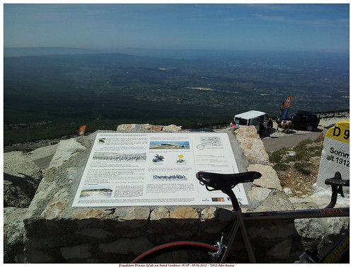
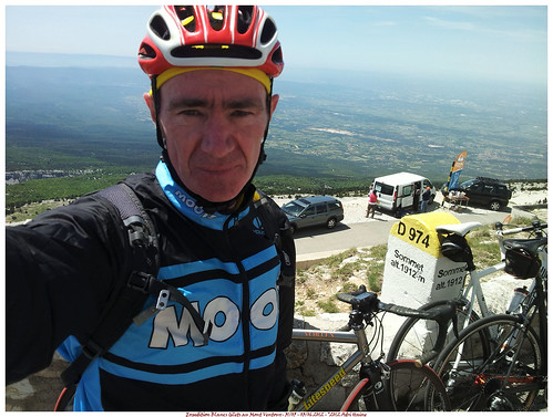
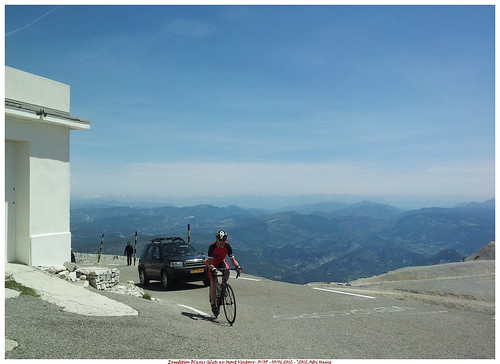
The view from the to is simply amazing. A 1600 meter vertical drop into the valley below where I can spot Bedoin and literally see for miles. On the other side the white caps of the Alps, some 100K to the east, are easily spotted. The wind forces me into a jacket and the temperature up here is an easy 23 degrees, some 10 degrees colder than the valley.
After some time we decide to move on and drop down into Malaucene, some 23K further down the mountain. After 33 minutes and with an average speed of 47 kph we arrive at Malaucene and settle down for a good meal. We have certainly earned it.
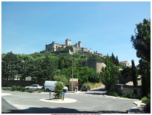
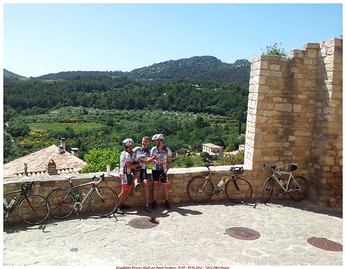
We continue our ride with a loop towards Suzette and Le Barroux. We spot the Dentelles de Montmirail as we go over the Col de La Chaine. We stop at the chateau de Le Barroux for a little pause.
Riding on towards Caromb and Modene we made it back into Crillon-le-Brave. It was a memorable ride and I thoroughly enjoyed it, in hindsight.
The evening saw us taking the car into Avignon for a dinner at the "Filles au Piano" dans the Rue Galante.
Endomondo track
Ride Stats : 72K and 2300 heightmeters (Garmin) in 04h05mins
Saturday June 2nd: Les Gorges de la Nesque
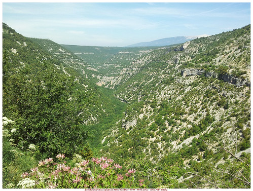
The legs felt a little less 'estival' today so we quickly decide to take it easy in the first couple of kilometers . Making our way along Flassan towards Auzo where we started the ascent towards the Gorges de la Nesque. The road here has a very steady climb in it that takes you for 18K along one of the highlights in this area, the 300 meters deep Gorges de la Nesque. The sun was out and even though the legs didn't feel very willing to ride I thoroughly enjoyed the beautiful landscape. Stopping at the culminating point to take a picture, I could see the Mont Ventoux looming in the background. Omnipresent it is.
We rode on until we came to Monieux. Here one of my friends knew a great restaurant so we took a long break whilst enjoying a fine meal in restaurant Les Lavandes
After the meal we crossed the Nesque and started the slow steady climb towards Javon along the N90. On the top we had another great view accross the Gorges towards the Mont Ventoux.
Moving on and now a very long downhill awaited us, bringing us from a height of 830m into Methamis where we rode on into the valley towards Mormoiron situated at 203m above sea level. From here it was a breeze in the sun and with only a light wind to make our way back towards the Gite at Crillon-le-Brave. A very fine ride with a great lunch at Momieux.
Endomondo track
Ride Stats : 81.5K and 1700 heightmeters (Garmin) in 3h37mins
4062/45315
31-05-2012, 00:00 geschreven door Big Bad Wolf
|
|
|
|
|
| 28-05-2012 |
| Boucles de Lasne |

Set out to help my club - The Blancs Gilets - with the organisation of the Boucles de Lasne. I received the GPS track of the 60K and left at 7am with another rider to check out the arrowing of this loop. After 5K we already got some trouble because we arrived in a area where all of a sudden the arrows arrived against our track. A lot of checking, re-checking and then calling Eric Anris, the guy who sleeps on these tracks. He told us we missed an arrow, the arrow was gone, and therefore were in the opposite direction of the track. We continued and the trail was a beautiful mix of climbs and descents, sometimes along very narrow trails. My legs were feeling tired and I was praying for the first feed zone to come along when Eric Anris called me again, and picked us up in his truck to ride us back to the place where we missed the arrow. Seemed that the arrow had been removed again, and again lots of mountainbikers were experiencing what it felt to be lost.
So we were supposed to ride this loop - 4K long and about 85 heightmeters until the last of the entrants had passed. I believe we did it six times, you can see that in the height profile.
Around 11:15 we rode back to the start. My Samsung Galaxy S II suffered from a flat battery so I decided to call it a day and get in my car. This is a nice organised ride and I am sorry that I could not complete the full 30K loop we were supposed to control. But as I have said, I have the GPS track so I can always come back again to ride it on my own.
Endomondo track
Ride Stats : 39K and 975 heightmeters (Garmin) in 2h53mins
3886/41210
28-05-2012, 13:33 geschreven door Big Bad Wolf
|
|
|
|
|
| 25-05-2012 |
| Meerdael Bloso |

A nice sunny day with a stiff breeze from the east.Around 27 degrees C when I rode out in the late afternoon. I had the Moots YBB back with a new nipple in the back wheel and the front wheel where the play had been adjusted. I felt good and maintained a good pace throughout the ride. I rode the Meerdael Bloso routes, in the opposite direction. Starting out with the Red , then hopping on the more intense Blue and finishing off with the Green. The pace was high. Too high for another nipple in my back wheel. I noticed it was out of tru whilst riding and when I arrived home I was abhorred to find out that another nipple had been broken off. I was not the same as last week but it is disturbing that this happens so fast after the other one. Maybe I need to have them all replaced, to be on the safe side.
Despite this I had a great ride. The trails were great, dried out after yesterdays' mild rainfall at the end of the day. With an average temperature of 23 degrees C it wasn't too warm to ride in long trousers and sleeves either.
Endomondo track
Ride Stats : 56.5K and 575 heightmeters (Garmin) in 2h36mins
3776/39705
25-05-2012, 22:22 geschreven door Big Bad Wolf
|
|
|
|
|
| 21-05-2012 |
| Climbing session |
 Lots of wind but warm and dry. So I set out for a bit of offroad climbing in the Kluis area. I found another climb I could incorporate into my loop there so one pass now yields me 4 climbs , 4.4K and about 135-140 heightmeters. Not bad. I did 3 loops and then rode back home with a good amount of heightmeters and a good feeling in my legs. Not too tired, just satisfied.
Endomondo track
Ride Stats : 25.5K and 605 heightmeters (Garmin) in 1h41mins
3688/38885
21-05-2012, 19:00 geschreven door Big Bad Wolf
|
|
|
|
|
| 19-05-2012 |
| Unfinished business on Meerdael Classic Trails |

With the weather sunny and dry I decided to ride out again on the Meerdael Classic trails. I felt a bit bad about not being able to complete them yesterday - due to the technical problems I had with the Moots YBB - so today I took the Hilset Big Bad Wolf custom out for the same ride. I cut the entry towards Pecrot a little shorter than yesterday and also altered the trail going through the valley on my way towards Ottenburg. From Ottenburg I picked up on the Meerdael Classic trails . The Hilset is almost 2kg lighter but non-suspended. To my surprise it turned out to be a lot faster on the trails. This might be due to the fact that I felt better than yesterday even though the BBW gives its rider a good beating due to the lack of suspension. On the uphills - and there were a lot of them today - it is 2kg lighter which makes it more agile. Even on the very steep hills the low 22/34 gearing - as compared to the Moots' 26/34 helps me a lot. Only the Moots does offer better grip in the rear when the going gets stony, rooty or loose.

Completing the ride through Meerdael Forest I had a sense of satisfaction of having done the climbs I did not do yesterday , and complete the Meerdael Classic Hills trails.
Endomondo track
Ride Stats : 56K and 860 heightmeters (Garmin) in 3h09mins
3662/38280
19-05-2012, 16:53 geschreven door Big Bad Wolf
|
|
|
|
|
| 18-05-2012 |
| Meerdael Classic Hills |

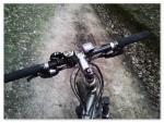
Today some rain was forecast so I was unsure wether to ride out. At 10.30 though I noticed the sun was out and the radar did not show any cloud cover dense enough to contain rain. So I took the YBB out for a tough ride. I planned to do the hilly section of the annual Meerdael Classic ride. This starts in Oud--Heverlee and passes near my home. It was here that I picked up on the trail that would lead me through Meerdael Forest to reach Nethen and later on Pecrot where the serious - hilly - business would commence. I took a bit of a risk to ride out with a rear wheel that suffered a bad bump during my latest ride with this bike. Later on that would prove to be exactly right.
The ride progressed well through a sunny and green Meerdael Forest and I was enjoying the silence with only the wind and the angry bee sound of my Chris King hub breaking the calm. When I reached the Klabbeek area things started to happen. On the uphill following the steep downhill at the Tomme, some 17K into the ride, my chain got stuck in a chainsuck whilst dropping to the small ring. I could get it free whilst backpedalling but I noticed a clanging sound from then on. At the top of the hill I stopped and noticed that the chain was twisted, one of the links was stiff and collided with my jockey wheels. Later on it got worse and caused the chain wanting to shift on the bigger ring all by itself. I decided to stop and break the chain, throw away the bad link and replace it with a SRAM locking link.

That went well and I set on for the rest of the ride. One hill after the other was absorbed by my legs and the sun was now hiding behind some darkening clouds. But it stayed dry and whilst I was pausing for a Clif Bar I noticed to my horror that one of the spokes in my rear wheel was loose. It had broken the nipple out of the rim. This was potentially a great risk so I decided to cut the ride short. One loose spoke puts more tension on the spokes next to it, and if they fail as well, the wheel collapses. Good thing I noticed this. I reckon the damage had been done during my latest ride, when I hit the big bump that caused my wheel to go out of true. Probably I hit another big one during this ride - it happens all the time, this is mountainbiking after all - which caused the already straining nipple to give out.
 Riding home though Meerdael Forest I did not encounter any more problems and was a bit sad having to cut short this ride. But I still put in a good workout which yielded me 10K and about 150 heightmeters less than I had bargained for.
Endomondo track
Ride Stats : 50K and 890 heightmeters (Garmin) in 3h04mins
3607/37420
18-05-2012, 15:15 geschreven door Big Bad Wolf
|
|
|
|
|
| 17-05-2012 |
| LF6 |

Today promised to be one of the better days of this week. So with it being a holiday I decided to get a solid 100K ride in. Taking the Hilset BBW out for a ride along the LF6 Vlaanderen Fietsroute would yield me exactly what I wanted. Starting out through Mollendaal Forest the LF6 then goes through Bierbeek, Meldert, Hoegaarden and makes its way to the East. Tienen and Landen are passed and when I arrived in Velm I knew I only had a couple of kilometers to go to reach the 50K mark. Unfortunately the LF6 signs disappear past Velm and I had to make do by following the Haspengouw Kruispunten routes. Riding up to No185 and then following the route towards Kruispunt No184 I crossed the little river Circidia and stopped at a little resting place to have a crispy Clif Bar that would fuel me on the way back.

Turning around I had the wind more or less in my back which made for an easier ride back home. The weather was great. Temperatures of around 16 degrees C and a mild wind from the southeast. And dry. Had a great ride.
Endomondo track
Ride Stats : 106K and 790 heightmeters (Garmin) in 4h41mins
3556/36530
17-05-2012, 16:43 geschreven door Big Bad Wolf
|
|
|
|
|
| 13-05-2012 |
| Meerdael Fun |
This morning I felt the aftereffects from yesterdays' ride. My legs were still recovering and I had a bit of a headache. Watching the Nove Mesto World Cup races and a couple of aspirins took care of the headache but I had to wait until the late afternoon before I felt Ok to get on the bike again for an easy recovery ride in Meerdael Forest. I set out along the Red Bloso, picking in on the Blue and then decided to follow this, with a few excursions and shortcuts along the way. I made a little detour into the Justin Scheepmansstraat, coming from the Zoete Waters on the Meerdaelweg, to take a picture of the blooming rapeseed in the fields.

Moving on, taking the exciting singletrail downhill into Sint Joris Weert and then back into the forest for the remainder of the Blue.Taking an alternative downhill towards the Savenel wall I spotted a fox on the long uphill. Arriving at the top I took a right for another exciying downhill along the field overlooking the Savenel wall again. Making it to the Grezstraat and taking a picture of the forgotten trail I came out of.

Back on the Red in the reverse direction to make it home with a little over an hour in the legs and an easy 119bpm average heartrate.
Endomondo track
Ride Stats : 26K and 365 heightmeters (Garmin) in 1h22mins
3422/35310
13-05-2012, 20:11 geschreven door Big Bad Wolf
|
|
|
|
|
| 12-05-2012 |
| Hallerbos and Dworp |

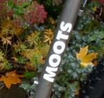
I had a good plan for todays' ride. It looked like it would stay dry so I wanted to ride out for a long ride. The first one on the Moots YBB this year. This bike got new NoTubes fluid in its tyres and also a new chain, cassette, middle and big ring over the winter recess.
I had plotted out the Beersel Green trail on Mapsource and combined that track with a shortened version of the 35K Hallerbos roadbook I have ridden a couple of times. This yielded me a 40K/800 heightmeters track I saved on my Garmin 705.
Riding towards Hallerbos along the usual way, passing next to the Margijsbos, de Ganzepoel and then into the Sonian Forest at Duisburg, to emerge at the Middenhut whence I rode along the Zonienwoudlaan until I could pick up on the Green trail in downtown Alsemberg. The Green trail turned out to be a very nice trail. Lots of climbing and the signage was perfect. Some of the tracks are only singletracks and the trail twists and winds itself in a big counterclockwise loop around Dworp. At one point I noticed Brussels on the horizon and I also saw the Sint Pieters Leeuw tower looming in the distance. The sun was peeping through the clouds and it became a couple of degrees warmer. But still it was only 12 degrees out there today. But that suited me fine. Moots windstopper, long trousers and I didn't need to worry about getting too warm.
When I reached the Rilroheidestraat I was on the second of my planned loops for today. Into the Hallerbos for some great trails with also a lot of climbing and descending into the many valleys. The hyacynths were nearly gone but here and there they still were in bloom.
Stopping for a snack because I felt this ride drain the energy out of my legs at a quick pace.
The bike was OK except for the front derailler that was set up a little bit tight on the outward throw because I could not shift on the big ring most of the time. I need to adjust the throw just a little bit so that the cage goes a couple of mm more to the outside, making the shift to the big ring a sure thing.
The last couple of kilometers came and passed and I was back at the Rilroheide where I picked in on the Beersel Green trail again. This last section proved to be quite difficult. A combination of me getting tired and the climbs getting steeper, making my way towards Alsemberg again. I was glad to see the big church which meant I was nearly at the point where I got on the route, a couple of hours ago.
Riding back home along the Zonienwoudlaan I knew I had to pace myself. The wind was blowing in my face and I was glad for the cover of the Sonian Forest. Coming out of it into Duisburg was tough again . The legs were feeling really tired now and I also felt my shoulders and arms stiffen from the hours of biking. But I made it and it felt good to have such a solid ride out again after a couple of days of staying off of the bike due to the varying meteorological conditions. I include the GPS tracks of both the Beersel Green Route and my Hallerbos 20K ride for those who want to try either - or both - of those for themselves. Be warned, the region is quite hilly and both trails offer nearly 400 heightmeters for a 20K ride, that a HillFactor of 20.
Endomondo track
Beersel Green Route at EveryTrail
EveryTrail - Find hiking trails in California and beyond
Hallerbos 20K at EveryTrail
EveryTrail - Find the best hikes in California and beyond
Ride Stats : 108K and 1540 heightmeters (Garmin) in 5h40mins
3397/34945
12-05-2012, 18:35 geschreven door Big Bad Wolf
|
|
|
|
|
| 07-05-2012 |
| Duisburg Red |
It remained dry for the entire day and the temperatures were climbing towards a mild 16 degrees C. I rode out in the late afternoon with a definite plan. Riding over Korbeek Dyle and high over Leefdaal to reach the point - just before Duisburg - where I had left the new Duisburg Red BLOSO route a couple of weeks ago. I was set on finding the missing arrow in Duisburg so I started on the loop. A nice descent along the edge of a forest brought me to a tarmac road which I had to ride upwards towards Duisburg for a while. Taking a right turn and down along a field road into a hollow road. Left into the village and to the point where I got lost last time. But this time I spotted the Red arrow that eluded me before. Taking me into the Sonian forest towards Tervuren. Good trails here and crossing the Duisburgsesteenweg to take a long climb into the Kapucinnenbos. Taking a left along a trail that was pretty muddy at times. Flat so no way for the water to drain. Luckily there was a parallel track that was dryer. Reaching the Dronkemansdreef , crossing that and then a nice uphill followed by a zooming downhill. This will be a fast one when it is dry, now care had to be taken because there were some slippery muddy patches that needed to be avoided.
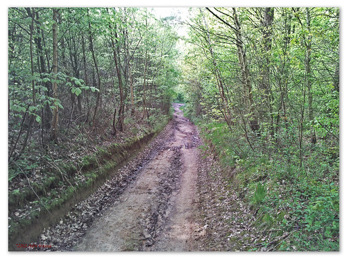
Down all the way and then along the forests' edge for a long loop, partly on tarmac, that took me back onto the Dronkemansdreef. Another muddy stretch before riding down towards the Duisburgsesteenweg again. Following this to the right care has to be taken because the trail takes a narrow path between houses , crosses the Achterstraat and continues on another path - broader this time - and then loops to the right and uphill to reach the Heidestraat. Another narrow path leads to the Pachthof Stroykens, where I assume the route starts. In the forest I noticed also Blue arrows and I did also see a Red/Green split so I think there must be 3 routes. I continue on the Red that now takes me through the fields towards the Veeweidestraat. Crossing this another uphill in a hollow roads takes me into the fields again and before long I reach the point where I injected myself on this track. Not bad for an easy ride with a couple of nice sections you might be tempted to do twice just for the fun of it..
Riding back home I took an alternative path towards Leefdaal. Alongside a big sandpit that is about to be exploited. A nice between-the-houses track leads me down towards the Schaveystraat. A new trail found ! I finish off through Meerdael Forest and am home just in time to avoid dusk.
Endomondo track
Duisburg Red Bloso at EveryTrail
EveryTrail - Find the best hikes in California and beyond
Ride Stats : 50.5K and 535 heightmeters (Garmin) in 2h30mins
3289/33405
07-05-2012, 22:04 geschreven door Big Bad Wolf
|
|
|
|
|
| 30-04-2012 |
| Mollendaal Tracks |
Warm weather this evening so when I got home from work I took the Hilset BBW and ventured into Mollendaal Forest for a quick dash around my winter trail. Adding a climb I normally would not do but since it looked already well dried-out - mainly due to the hight temperatures of yesterday afternoon and today - I took the risk and it turned out OK. The weather felt heavy and it might turn into a thunderstorm later tonight.
But for now I enjoyed good trails and heavy legs. It looks like I need to rest a day to allow my body to recuperate fully.
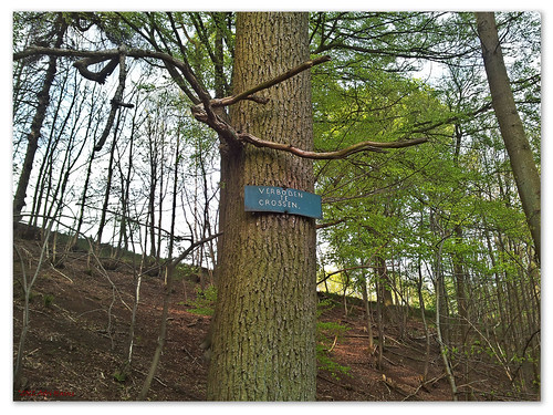
I was surprised I still was close to a 20kph average. It didn't feel that quick. Stopped once to take a picture of what looks to be a frowning tree. There are a couple of them to be found high in the forest, close to the Mollendaal rift.
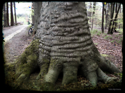
Dropping into said rift and climbing out again I arrived near the Bremberg for a last loop alaong Blanden cemetery and back into the forest.
Endomondo track
Ride Stats : 28K and 365 heightmeters (Garmin) in 1h29mins
3048/31395
30-04-2012, 20:08 geschreven door Big Bad Wolf
|
|
|
|
|
|
|
| Gastenboek./.Guestbook |
Druk op onderstaande knop om een berichtje achter te laten in mijn Gastenboek. /
Press the button below to write in my Guestbook.
|
| Email Me |
Press the button to send me a mail
|
|
|
|