 |
|
|
| Tales from the Woods |
|
|
| 30-05-2009 |
 O2 Bikers Roadbook Harzé O2 Bikers Roadbook Harzé |
When rising I found the sun out, and a beautiful day was announcing itself. Temperatures in the low 20-ies and a stiff breeze to keep things from getting too hot. Great day for a ride.
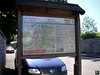
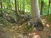
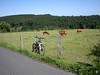
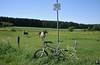
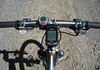
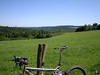
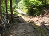
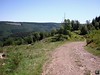
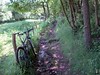
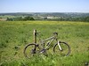
So I rode the red Mazda to Harzé, a little town not far from Aywaille, in the province of Liege in our Belgian Ardennes. An hour later I was setting up the Merlin for the start of the roadbook I was going to ride. I got it from the O2 Bikers website. Upon checking the trace and given the beautiful area, I didn't hesitate to select this ride for a closer inspection. Directly from the beginning, the tone was set. A steep singletrack leading away from Harze. I had to select the small ring in front, it wouldn't be the last time today, to cope with the hill. My heartrate went up in the 140-ies , the bike's suspension was moving gently beneath me, life was good. A short rest on some flatter terrain upon reaching the top of the ascent, and then the trail disappeared into a dark forest. Upon reaching the Bois du Pouhon the drop downhill in the dense forest was a technical one, to the point of being unrideable at certain stages. Too many rocks, mud and some water flowing on the track forced me to walk for a couple of times. When the descent got better I rode again, and emerged at the St Anne's chapel near a small town called Paradis. A very steep and long ascent on tarmac brought me back to the 400 metre mark and into another forest. I was nearing the E25 which I undercrossed by means of a dark and flooded tunnel. The bike got a good wash and the first couple of braking sections had my front brake squealing. When the forest cleared out I could see the Ambleve valley to the right of me, with the green hills on the other side reminding me of some great rides starting in Theux and leading down into the Ninglinspo valley.
But today I was on the other side of the Ambleve and a big downhill was slowly announcing itself. Some sections were very ride-able but others were dark, wet and muddy. During the last parts of the descent I follow a little rivulet, the Fagne Naze which leads me to the borders of the river Ambleve.
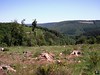
Here I am at the lowest point of todays ride - 183metres - and this means one thing, I have got to climb! And what a climb it is . After having taken a wrong turn into a private forest - GPS reception is very bad in these narrow valleys - I find the right track which will lead me back up the hill. A long climb with more than 200 heightmeters in one go. Not too steep so the chain can remain on the middle ring while I enjoy the soft sounds of the forest - some small rivers babbling to my right, every now and then I hear some animals making noises while they run away from me - and the sound of my tyres on the rocky road. Upon reaching the top I follow some tarmac for a while which is a welcome recuperation point. Then the road becomes a track again and I zoom downhill into the Bois d'Aywaille. A sharp turn to the left and I am on a trail that is also used in the O2 Bikers roadbook of Nonceveux, which I did last year. The thought of combining these two roadbooks crosses my mind. But with 75K and more than 2000 heightmeters that will be quite a challenge. Perhaps something for the Summer or the beginning of Autumn.
   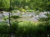   
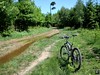
For now I have to remain vigilant because after undercrossing the N25 again, yes, though another dark and wet tunnel, the track becomes technical again with a rocky downhill into Kin. A small girl on a bike joins me when I ride though this small village before turning away into a steep singletrack that leads me along a barbed-wired field. The track is very difficult with roots and rocks and the thought of the barbed wire on my left makes it more difficult still. But i make it and the next forest awaits me. A great passage with a downhill into La Bordai that makes me happy I got the Merlin for this ride. Rocks, ruts and the occasional puddle keep things interesting. After a 180 to the left the trails goes upwards again along a small track, so small that the nettles have a feast on my legs and arms. Ouch. Another river crossing and I'm getting a glimpse of Harze to the left. After a last bit of forest track I come upon tarmac which leads me back to the starting point.
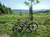
This was a great ride, some bits were very (too! ) technical and there are some tarmac passages which do come handy because they allow some recuperation. There is water everywhere in these areas and I wouldn't recommend these trails after a heavy downpour. It has been a couple of days since the last rain but I could still see a lot of mud and puddles. Most of them can be avoided but at times you have to walk a small section. Especially the downhill leading towards the Chapelle St Anne will be too much for most of us mere mortals. The risk of falling when attempting to ride it is great. The trails moves in and out of forests all the time but the sun can burn here, so take precautions when riding these trails in spring or summer. A full suspension bike is to be recommended but of course a hardtail will also do the job , it will put more strain on its rider though. I didn't really feel tired after this ride and I contribute this for the biggest part to my Merlin Works 4.0 bike which just seems to float over the trails.
Ride Stats : 40,5K and 910/920 heightmeters (Polar/Garmin) in 2h50mins

Hill Factor : 22,7
GPS track on Motionbased : CLICK
3766/36175
|
|
|
|
|
Reacties op bericht (0)
|


