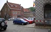
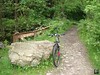
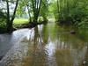
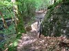
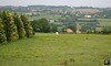
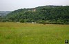
After having ridden the excellent - technical, beautiful scenery, masses of heightmeters - O2 Bikers roadbook of Nonceveux last year, I kept my eye open for similar pearls . When I saw the Polleur roadbook in the April 2009 issue I didn't have to think twice. I wanted to ride it, asap. I know the region between Remouchamps, Banneux, Verviers, Theux and Spa pretty well and I haven't been disappointed when riding there. The area is very beautiful, the valleys are deep and lush with big forests and fields vying for every bikers' attention. The region is also very Ardennesque, with rocks and roots galore and a plethora of steep and technical ascents/descents. Furthermore, this roadbook descents towards the river Hoegne, known to me from my Longest Downhill adventures. And recently also by riding the Verviers World marathon Championship tracks. In short, I wanted to go. The weather forecast called for dry weather but with increasing thunderstorm possibilities in the late afternoon. After having checked Meteox this morning and seeing not a menacing cloud within a couple of 100 kilometers I rode my car to Polleur.Around 10am I parked the red Mazda in front of the librairie de Polleur, straight across the church. This church is a bit special, I already mentioned this in my Verviers blog entry, but for those who are new here, just check out the rotation in the roof.After 15 minutes I was on my bike and already riding uphill. The track quickly descents towards Neufmarteau where I meet the river Hoegne. The trails are wet, this added a couple of points on the difficulty scale. It is utopic to expect an Ardennes ride to be dry, but the less water the better. They call this area 'l'Ardenne Bleu', and I'm sure the Blue stands for water. I asked the locals and they said they had a big thunderstorm 2 days ago. Ceci explique Cela.. This explains that.The first couple of climbs have me looking for a good rhythm. I have stopped taking the Aerius hayfever pills last week and I'm not feeling too well. Still, I'm persistent I might not need them anymore. We'll see. The tracks are difficult, wet, rocky, steep and demanding . Yip, thats the way I like them. My pace is slow but I'm enjoying every minute of it. Slowly I crawl out of the forest for a bit of field before descending towards Surister. Then a long drop back towards the river Hoegne. Tricky and the wet rocks demand the utmost of my concentration. But I am determined to ride it all and amazingly, I make it.
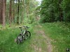
Into Royompré and then a beautiful singletrack ondulating high above the Hoegne towards the Croupets du Moulin. A tough one, wet and rooty and the drop on the left doesn't look very forgiving. A fallen tree has me climb over it, bike in hand. Another long climb leads me through the Bois de Rassouster. Dropping back towards Royompré, crossing the N629 and I have to walk the first couple of meters of the following climb. Too rocky, too wet. After a while I leave the forest and follow a narrow singletrack towards Les Bansions. When I arrive on a bigger trail I take some time to eat. The next couple of kilometers are a bit easier along the Bois des Gattes but with a nasty descent - rocky and wet - at Le Sarpey before reaching Polleur again. Here the trail merges with the Red Theux route and climbs into the majestic Bois de Staneu. The trail crosses deep under the E42 bridge and then follows a track parallel to the Red route. This track is the most difficult of the day, actually riding in a rivulet, its bed riddled with rocks. The Moots has to work hard here, and its rider even harder, the wheels keep slipping, bumping against rocks, process is slow but steady. This bike was made for this. The trail then descents towards the road leading from Polleur to Theux, but just before reaching it you have to take a sharp left and brace yourself. A steep climb follows. I made it but it cost me a lot of energy. Then follows a wet section, lots of puddles, as the trail remains on the same heightline for a while . It drops back down again, turns to the left again and the biggest baddest of climbs follows. I admit, I didn't make it this time. I did when riding the Red last year with the Merlin, but the trail was dry then. It was wet now and the big rocks make every mistake a bad one. About halfway to the top my rear wheel slipped and I didn't have the strength or speed to correct it. OK, walk this way. After a while the slope became less steep and I could ride on. The trail is then dropping for the last time towards the road heading to Theux. Normally the roadbook follows this tarmac road into Theux but I decided to add another climb following the Red route upwards towards Rainonfosse. Then I zoom back down into Theux.
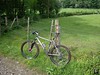
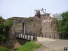
Next target was the Chateau de Franchimont. I had spotted it already a couple of times when riding in the Bois de Staneu but now I was at the bottom of the climb leading up to it. You have 2 options, one is 1350 metres long , the other 350 metres. No points for guessing which one I took. The hill was short and steep. 32% to be precise. Luckily it was also dry so I made it without too much difficulty. After having stopped to take some pictures I started on the last 7 kilometres leading me towards the top of the Thier de Polleur, a 26% drop into the town of Polleur where I had to be careful one last time before reaching the end of the roadbook.
Ride Stats : 36K and 790/820 heightmeters (Polar/Garmin) in 2h38mins

Hill Factor: 22
GPS Track on Motionbased : CLICK
3550/33405
|