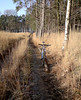
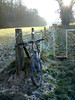
Another clear, crisp and cold day and I was eager to ride out. I had been contemplating doing the O2 Bikers Grez Doiceau roadbook for a while now and in these sub-zero conditions the trails would be ideal. No mud, at least I expected none, just dry hard trails. I know the region around Grez Doiceau intimately, it is one of my favorite training spots. I know the trails of the Accro Bike and the Belgian XC Marathon Championships by heart. My club - the Velo Club Grez Doiceau - organised those championships this year with start and finish in neighboring Pecrot. The Accro Bike is a ride that has been organised for many years and I frequently ride along its 42 and 55K versions. O2 Bikers had contacted me a while back to help with a roadbook but in the end they decided to take another guide. In the crucial period I was lying in my bed with a slipped disc. So I was curious what they had concocted. I downloaded the roadbook into my Garmin Edge 705 GPS and around noon I started out. The first 10K took me towards Grez Doiceau and they helped me warm up - the word is ill-chosen - and acclimatize to the sub-zero temperatures. A strong easterly wind made it feel a lot colder than it already was. It was this wind that I feared the most. From the town square the track immediately ascends towards the Bois de Bercuit. At the end it was too steep to ride, especially since a lot of horses hooves has made a fine mess of the trail , mess that was frozen solid and does not help you keeping things rolling when on a 20% incline. So I walked, no shame, it was winter and I would need all my strength to get me around these trails. The trail then descended towards Dion Valmont only to ascend again via a hollow road and a field track towards the N25 . From there I plunged back into Dion and gradually made my way towards Bonlez. The steep ascent towards Les Gottes had me walking again but the section that followed was quite nice. Into the Bois des Gottes they had found a nice track with some high grass next to it. This section was new to me. Into Bonlez then where the trail veered to the left between two houses to reach the river 'Le Train'. Obviously there was some ice and at places even mud here, so close to the river borders. Again, horses hooves had made a mess of an otherwise fine trail. But after a couple of hundred meters the track became dryer and I could follow the singletrail along the river all the way to Inchebroux. A great section into the Bois de Chaumont, with some familiar trails and also some opportunities for extra climbing they did not include. The tricky downhill towards the Rue du Try - or rather an extension of that road leading into the forest and consisting of nothing more than a little river which the trail follows - had me concentrating myself on negotiating the steps, gullies and debris. Down into the gulley - which was partly frozen so dryer than usual, thank God This gulley actually feeds the Glabais rivulet which merges into the Train in Bas Bonlez . I followed the forest road obviously and arrived at the Pink Fishery. Here the trail veered to the right along a singletrack between fields to plunge down into the forest de Glabais. A nice and well known section here with a lot of climbing and descending to arrive finally into downtown Hèze.
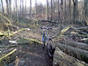
The trail then climbed up towards the road to Longueville. I would follow this road briefly before plunging into a field road again which led me towards a forest. Here the trail was nicely blocked by trees . I had to walk a couple of hundred meters which was a pity because it is a nice track plunging into and climbing out of this forest. A little later I was plunging into another forest, very steeply , to follow another singletrack which led me nicely into Pietrebais. Here I got a little surprise - an unknown track close to the river Pietrebais which led to the Rue de la Frene. Here I encountered a well know track which led me up towards the Ferme de la Sarte. I then descended into Cocrou, crossed the Chaussee de Jodoigne and began the last climb into the Bois de Beausart. Steep rooty downhill alongside the Bois de Linsmeau and a few fieldroads later I was back in Grez Doiceau. In all a very interesting trail and certainly a good alternative to the Accro 42 trail. With 34.8K and between 550 and 580 heightmeters its well worth checking it out. The last 10K which took me back home from Grez Doiceau had me exposed to the wind and I was glad I reached Hamme Mille where the shelter of Meerdael Forest protected me nicely until I was home.
Ride Stats : 56K and 725/726 heightmeters (Polar/Garmin) in 3h37mins
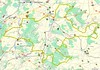
O2 Roadbook Grez Doiceau Stats : 35K and 543/554 heightmeters (Polar/Garmin) in 2h32mins
O2 Roadbook Grez Doiceau Profile:
O2 Roadbook Grez Doiceau Map:
10181/95775
Reacties op bericht (0)
Gastenboek./.Guestbook
Druk op onderstaande knop om een berichtje achter te laten in mijn Gastenboek. /
Press the button below to write in my Guestbook.